

 یورپ کے شاندار جغرافیائی عجائبات - اہم قدرتی نشانات">
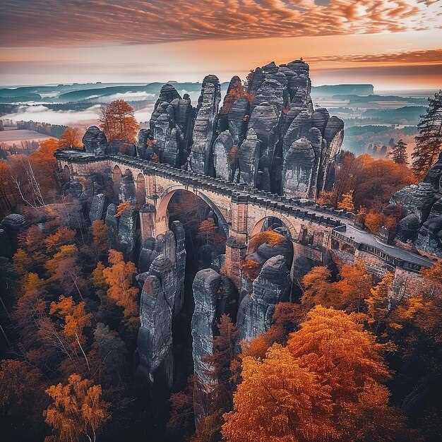
Plan a sunrise visit to the Swiss Alps to see the peaks glow with first light and photograph serrated silhouettes above pine slopes.
Then travel along Norway’s fjords, where long glacial arms reach toward the sea. A خاموش vessel cruise along the water reveals sheer rock faces and cascades that plunge into sheltered inlets.
In Croatia, Plitvice Lakes National Park presents layered terraces with turquoise pools linked by cascades, set among dense woods and a thriving avifauna along the paths.
Italy’s Dolomites and the Matterhorn offer alpine panoramas; pyramidal peaks rise above glacial valleys, inviting hikers to plan multi-day routes around high passes.
In Iceland, Gullfoss and nearby geothermal fields show a dynamic mix of ice and steam, while Vatnajökull holds vast ice that feeds rivers across the highlands.
عملی نکات: visit early, wear sturdy footwear, and allocate a couple of hours for each site to enjoy clear views and quiet moments.
Gouffre Berger, France: Practical Guide to Exploring Europe’s Deepest Cave
Plan your descent with a licensed guide; youll need a booking and a safety briefing before entering Gouffre Berger. Referred to as Europe’s deepest cave, Gouffre Berger in France’s Isère region offers a completely subterranean world where the interior unfolds through a sequence of shafts and dimly lit galleries. The surface approach is simple, but the exploration inside demands focus, steady rhythm, and respect for the cave’s delicate balance. The scenery above ground remains picturesque, with birds circling above the entrance as you prepare; the underground passages reveal a powerful, great contrast that leaves visitors marveling.
Gear list: helmet with secure chin strap; headlamp with two back-up sources; sturdy boots with grip; a durable harness and rope kit; warm, moisture-wicking layers; a waterproof shell; and a small pack with water and snacks. youll carry a spare light, batteries, and a compact first-aid kit inside. Guides handle fixed lines and anchors; do not improvise. With proper conditioning and rope techniques, the descent to the largest sections can take most of a day; pace yourself and listen to your guide.
The interior features dimly lit galleries, underground lakes, and the constant hum of running water. The route may require wading through shallow pools and careful footwork through slick rock. Falls create echoes that sharpen eyes and contribute to the sense of scale; the space feels powerful yet open and simple in some sections, while hiding complex passage networks elsewhere. Visitors should remain respectful of the environment, keep hands free for rope work, and listen to the guide’s instructions. For some, the textures on mineral formations evoke lascaux-like patterns, a curious link between prehistoric art and modern exploration; marveling at this contrast helps you feel how humans have used cave spaces across the ages.
Getting there: take a train to a nearby French town, then a short bus ride or taxi to the trailhead. A single day trip is common for experienced groups, but many visitors prefer an overnight stay in a nearby village to allow for a calm start and exit before fatigue sets in. The entrance is modest, but the descent below ground is anything but; plan for a full-day schedule, and respect the opening times and safety rules provided by your guide, because the cave is dynamic and weather-dependent. Local guides, including a veteran named lovech, help newcomers with pacing, rope handling, and how to read cave signs.
Location specifics: Gouffre Berger’s geographical setting and access route
Begin with a licensed guide and enter Gouffre Berger only with a full team and proper gear. Inside the limestone cavity, the initial chamber opens into a wide passage and a tall shaft, delivering a spectacle that echoes the drama of the Matterhorn. Just as you step in, keep your headlamp bright and your pace deliberate, and respect fixed lines and rope sections. Padirac and Aggtelek are renowned centers in their own right, but Gouffre Berger centers on technical cave exploration in a way that demands coordinated teamwork and careful planning.
Location specifics: Gouffre Berger sits inside the Vercors limestone massif, within the Isère region of central France. The entrance lies just below a cliff on the plateau’s edge, inside a wooded hillside that frames a karst valley. The cave’s network formed as groundwater flowed through carbonate rock, eroding and expanding passages since the earth cooled. The system includes a deep cavity and a series of canyons and chambers, making it a landmark in European speleology and a full experience for skilled cavers–ahead of other famous examples such as Krubera, Mulino, Altamira, or larger cave complexes that show different karst dynamics.
Access route: Begin at the plateau trailhead above the valley and park at the designated pull-off, then follow a marked path that climbs to a saddle. From there, a short scramble leads down to the entrance; plan a 30–60 minute approach depending on conditions. Enter via the cleft and descend into the main passages with a guide; rope gear is required for vertical sections, and a helmet is mandatory. The longest vertical segments in the network require careful ropework and teamwork. Always check weather before you go, as rainfall can raise water levels below. For a safe, memorable experience, coordinate with a local speleological club, respect the environment, and use the center of your plan to understand how the earth’s flow has shaped these caves for generations.
Access, permits, and booking: steps to arrange a visit
Book online through the official park authority at least six weeks before your visit to secure entry permits and a specific time slot.
In regions like vatnajokull, many routes in protected zones require a guide and a permit; verify the rule for your chosen path with local authorities. If your plan includes a steep descent, ensure the guide is qualified for glacier terrain.
Consult the primary source of information on the park’s site or the national tourism portal to confirm which forms to submit and where to send them.
Lead times vary by season; summer slots fill quickly, so plan six to eight weeks ahead and note group size limits (often 8–12 participants per guide).
Prepare documents and gear; bring government ID, the permit receipt, weather-appropriate clothing, durable boots, a basic first-aid kit, and sun protection. youll want to keep the load light.
On the day, arrive early for check-in, present permits, and listen to the guide’s safety briefing. During the descent or ascent, follow the path markers and respect closures in place where necessary.
If you travel from ireland or majorca, plan buffer days for transfers and consider packages that connect multiple sights; you can align your stay with nearby places and hostels for easy access to the next site. The route often offers powerful scenery and adrenaline moments, with picturesque views that highlight the beauty of the region.
For curious visitors, some routes pass near paleolithic sites and even vilenica cave histories; guides may share greek myths to enrich the experience while you observe rock forms along the gorge.
Seasonal timing and conditions: when to plan your descent
Plan your descent in late spring or early autumn for most sites to balance daylight, weather stability, and crowd levels. For vatnajokull and other glaciers, expect variable wind and rapid weather shifts; this window keeps temps manageable and allows longer sunlit days without mid-summer meltwater floods. If forecasts shift, continue to monitor and adjust plans instead of forcing a descent into a risky slot.
Across the continent, microclimates demand site-specific timing: verdon’s south-facing cliffs warm up fast, target April–June or September–October; lamprechtsofen caves stay accessible with guided slots; capri’s sea-cliff experiences shine in late spring and early autumn when seas calm and suns arc lower for dramatic light. millions of light beams cross crystal walls, making ethereal moments. In borgio, coastal routes respond to wind and tides; in basilicata, pollino trails offer better conditions in May–September; you can continue planning with local guides for maximum safety.
| Site | Best Window (months) | Approx Daylight | Key Conditions | Gear & Access |
|---|---|---|---|---|
| vatnajokull | Mid-June to early September | 14–20 hours peak; wind risk possible | Glacier routes, crevasses, cold temps | First gear: helmet, crampons, ice axe; rope, harness; warm layers; waterproof boots; access requires permit |
| verdon | April–June and Sept–Oct | 12–14 hours in spring; heat possible in summer | Rugged limestone, potential floods in spring, sun exposure | Helmet, sturdy boots, rope systems; access through local guides; caution on wet ledges |
| lamprechtsofen | March–October (tours run year-round with schedules) | غار کی روشنی پر منحصر ہے 10-12 گھنٹے | آسمانی کرسٹل تشکیل; غار کا مسلسل درجہ حرارت ~8-12 C | ہیلمٹ، ہیڈلیمپ، گرم پرتیں؛ بک گائیڈڈ سلاٹس؛ غار آفس پر سائن ان کریں۔ |
| بورجیو وریزی | April–June and Sept–Oct | 12–16 گھنٹے | جنوبی سمت کی ساحلی چٹانیں۔ ہوا اور سمندر کی کیفیت اترنے پر اثر انداز ہوتی ہے۔ | ضرورت پڑنے پر چڑھنے کا ہارنس؛ ساحلی راستوں کے لیے لائف جیکٹ؛ مقامی اجازت نامے کے ذریعے رسائی |
| کپری | کپری | 12–14 گھنٹے؛ سمندری حالات مختلف ہو سکتے ہیں | بحری چٹانوں کے نظارے، فیری روابط؛ موسم گرما کے وسط میں بھیڑ عروج پر ہوتی ہے۔ | سی-کایاک یا کلف روٹس کو گائیڈ؛ لائٹ ہارنس؛ سورج سے تحفظ درکار ہے۔ |
| پولینو، باسیلیکاتا | مئی تا ستمبر | 11–15 گھنٹے؛ خشک موسم کو ترجیح دی جاتی ہے | پہاڑی راستے؛ موسم تیزی سے بدل سکتا ہے؛ جنگلی حیات | مضبوط بوٹ، ٹریکنگ پول، نقشے؛ جہاں ضرورت ہو اجازت نامہ؛ مقامی رینجرز کے ذریعے رسائی |
گیئر، تربیت، اور حفاظت: غار کی تلاش کے لیے تجاویز
ہر اترائی سے پہلے اپنے ہیلمٹ، ہیڈ لیمپ اور اضافی بیٹریوں کو چیک کر لیں؛ زیرِ زمین راستوں کے لیے روشنی کا ایک قابلِ اعتماد ذریعہ بہت ضروری ہے جو ڈرامائی انداز میں خود کو آشکار کرتے ہیں۔.
گیلے حصوں میں جمع شدہ جھیلوں کو تیر کر پار کرنے کی توقع رکھیں؛ الیکٹرانکس کے لیے ایک خشک بیگ، سوئم سوٹ اور کپڑوں کا جوڑا ساتھ لائیں۔ مضبوط اور گرفت والے جوتے پہنیں اور اضافی موزے واٹر پروف پاؤچ میں رکھیں؛ باہر آنے پر خشک ہونے کے لیے ایک چھوٹا تولیہ ساتھ رکھیں۔.
- ایک محفوظ چن سٹراپ والا ہیلمٹ اور اگر دستیاب ہو تو فیس شیلڈ کا آپشن۔
- پرائمری ہیڈ لیمپ پلس دو بیک اپ؛ واٹر پروف بیٹری پیکس اور اضافی بیٹریز۔
- رسی یا فکسڈ لائن جو روٹ کے لیے موزوں ہو۔ مبتدی افراد کے لیے 20-30 میٹر لمبائی کئی عمودی حصوں کے لیے کافی ہے۔
- مضبوط غار کھودنے والے جوتے یا گرفت پر توجہ مرکوز کرنے والے پیدل سفر کے جوتے اور گھٹنوں کی حفاظت
- الیکٹرانکس، دستاویزات اور اضافی کپڑوں کے لیے ڈرائی بیگ
- سردی سے بچاؤ کے لیے موسم سرما کے غاروں میں گرم تہہ اور ہوا سے بچاؤ کے لیے لائٹ ویٹ شیل
- فرسٹ ایڈ کٹ، سیٹی، اور ایک واٹر پروف نقشہ یا آف لائن نیویگیٹر
- پیمائش کی ٹیپ یا ڈوری گزر گاہوں کی چوڑائیوں، گراوٹوں اور اینکر پوائنٹس کی پیمائش کرنے کے لیے
- راستہ نشان زد کرنے کے لیے مارکر ٹیپ یا چاک اور نوٹس کے ساتھ ایک چھوٹی نوٹ بک
تربیت عملی اور ترقی پسند ہونی چاہیے۔ کسی اہل گائیڈ کے ساتھ غار کی حفاظت کا تسلیم شدہ کورس کریں، بڈی چیک کریں، اور اشاروں، واپسی کے وقت اور ایمرجنسی کے طریقہ کار پر متفق ہوں۔ پہلے خشک حصوں میں مشق کریں، پھر ہلکے گیلے علاقوں میں، اور آخر میں نگرانی میں عمودی نزول کی نقل کریں۔ شروع کرنے سے پہلے، اپنے گائیڈ کے ساتھ راستے کا جائزہ لیں، پورے راستے میں متعدد اخراج کے اختیارات کی تصدیق کریں، اور ہر حصے کے لیے حقیقت پسندانہ وقت کا بجٹ مقرر کریں۔ ایک پرسکون تال بنانا آپ کو توانائی کو منظم کرنے اور غار کے ایک طویل دن کے دوران توجہ مرکوز رکھنے میں مدد کرتا ہے۔.
موسمی منصوبہ بندی اہم ہے۔ سردیوں میں، ٹھنڈے پانی اور درجہ حرارت کی تیزی سے تبدیلیوں سے بچاؤ؛ نمائش کو محدود کریں اور اضافی گرم پرتوں کی منصوبہ بندی کریں۔ گرمیوں میں، ہائیڈریشن، داخل ہونے سے پہلے سورج کی روشنی میں جانے اور تھکاوٹ کی نگرانی کی منصوبہ بندی کریں۔ ہمیشہ ایک ایسا منصوبہ بنائیں جس پر آپ مکمل طور پر بھروسہ کریں؛ اپنے ساتھیوں کو اپنے منصوبے سے آگاہ کریں اور اپنے گائیڈ سے اس کی تصدیق کریں۔ جارجیا اور دیگر کارسٹ خطوں میں، موسم غار تک رسائی اور پانی کی سطح کو متاثر کرتا ہے۔ اس کے مطابق گیئر کو ایڈجسٹ کریں۔.
مشہور مقامات میں سیاق و سباق اہمیت رکھتا ہے۔ کچھ غاریں یونیسکو کے فہرست کردہ علاقوں میں واقع ہیں، اور مقامی قوانین کو اجازت ناموں یا گائیڈ کے ساتھ رسائی کی ضرورت پڑسکتی ہے۔ کارووییرو کے ساحل میں، ساحلی سمندری غاروں میں جوار کے بارے میں آگاہی اور کٹاؤ کا احترام ضروری ہے؛ نازک ساختوں کو پریشان کرنے سے بچنے کے لیے نشان زدہ راستوں پر رہیں۔ لاسکاؤ جیسی غاریں ہمیں یاد دلاتی ہیں کہ یہ وقت کے ساتھ مسحور کن ہے، اس میں طاقتور ارضیات اور ڈرامائی پتھر سیاحوں اور محققین کو یکساں طور پر اپنی طرف متوجہ کرتے ہیں۔ جارجیا میں، مختلف غاروں کے ماحول ایک تجربہ کار گائیڈ کے ساتھ دریافت کرنے کی دعوت دیتے ہیں جو خطرات کا اندازہ لگا سکتا ہے اور حفاظت کے نکات فراہم کر سکتا ہے۔ درحقیقت، غاریں قدیم انسانی کہانیوں سے جڑی ہوئی ہیں، جو وقت کے ساتھ ہر مہم کو زائرین کے لیے ایک بامعنی تجربہ بناتی ہیں۔.
قریبی مقامات اور سفر کے آئیڈیاز: اپنے یورپی غاروں کے سفر نامے کو وسعت دیں۔
پستوجنا غار، سلووینیا نال شروع کرو، ایتھے دستیاب اک بہت ای موثر تعارف دے لئی: روشن چونے دے پتھراں دے وچوں اک 90 منٹ توں تھوڑا اُپر دا رہنمائی والا واک جیہڑا لکھاں سٹالیکٹائٹس تے سٹالگمائٹس دی میزبانی کردا اے، جس دے بعد ہالاں دے وچکار اک مختصر ٹرین دی سواری۔ ذائقہ دے تضاد لئی بالکل مناسب ویلہ۔.
اس کے بعد، جنوب کی جانب باسیلیکاتا میں واقع پیرٹوسا-اولیٹا غاروں کی طرف جائیں، جہاں ایک 60 منٹ کی کشتی کی سیر ایک دریائی نظام کے ذریعے راستے بناتی ہے۔ روشن چیمبر زمین کے رنگوں کے پتھروں کو ظاہر کرتے ہیں، جبکہ سٹالیکٹائٹس چھت سے لالٹین کی طرح لٹکتے ہیں۔.
اسی علاقے میں آپ پیمانے کا موازنہ کرنے کے لیے جائنٹ غار (Grotta Gigante) بھی جا سکتے ہیں: لاکھوں سالوں میں بننے والے ستونوں والا ایک فلک بوس چیمبر، جو کشادہ راستوں اور ایک روشن، اچھی طرح سے روشن ماحول سے منسلک ہے۔.
اس کے بعد، شمال کی طرف آئس لینڈ کی طرف جائیں اور Vatnajokull کے نیچے برف کے غاروں کو دیکھیں۔ منجمد دیواریں سورج کی روشنی کو نیلے پہلوؤں میں منعکس کرتی ہیں، اور گائیڈ آپ کو روشن سرنگوں میں 2-3 گھنٹے تک لے جاتے ہیں، سب سے اونچے برفانی اشکال اور زمین اور برف کے درمیان دم بخود کر دینے والے تضاد کو نمایاں کرتے ہیں۔.
فرانس میں گُوفْرے ڈی پَڈیراک موجود ہے، جو ایک مشہور ترین کھائی ہے جہاں ایک لفٹ آپ کو خلا میں نیچے لے جاتی ہے اور ایک کشتی نارنجی اور سفید روشنی میں چمکنے والی چٹانوں کے نیچے ایک زیر زمین دریا میں پھسلتی ہے۔ یہ اسٹاپ آس پاس کی غاروں اور زمین کے اوپر گُوفْرے کے علاقے کو دریافت کرنے کے ایک دن کے ساتھ اچھی طرح سے جُڑ جاتا ہے۔.
آخر میں، یونانی جزیرے پر چھٹی کو منصوبے میں شامل کریں۔ یونانی ساحل سمندری چٹانوں اور جزیروں کے درمیان سمندری غاریں پنہاں کرتا ہے؛ آپ فیریوں، کشتی کے مختصر چکروں اور ساحل پر چہل قدمی کو ملا کر پانی پر سورج کی روشنی اور کارسٹ خصوصیات سے لطف اندوز ہو سکتے ہیں جو ساحل اور غاروں دونوں کو تشکیل دیتے ہیں۔.