

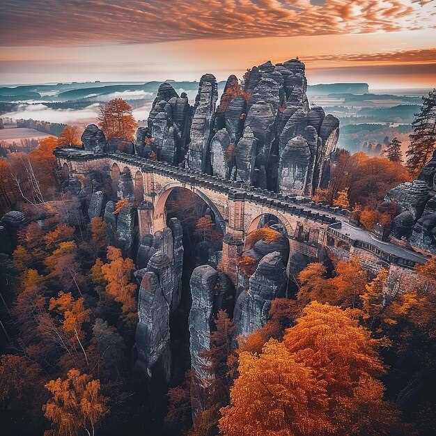
 פלאי הטבע המרהיבים של אירופה – ציוני הדרך הטבעיים המובילים">
Plan a sunrise visit to the Swiss Alps to see the peaks glow with first light and photograph serrated silhouettes above pine slopes.
Then travel along Norway’s fjords, where long glacial arms reach toward the sea. A quiet vessel cruise along the water reveals sheer rock faces and cascades that plunge into sheltered inlets.
In Croatia, Plitvice Lakes National Park presents layered terraces with turquoise pools linked by cascades, set among dense woods and a thriving avifauna along the paths.
Italy’s Dolomites and the Matterhorn offer alpine panoramas; pyramidal peaks rise above glacial valleys, inviting hikers to plan multi-day routes around high passes.
In Iceland, Gullfoss and nearby geothermal fields show a dynamic mix of ice and steam, while Vatnajökull holds vast ice that feeds rivers across the highlands.
טיפים מעשיים: visit early, wear sturdy footwear, and allocate a couple of hours for each site to enjoy clear views and quiet moments.
Gouffre Berger, France: Practical Guide to Exploring Europe’s Deepest Cave
Plan your descent with a licensed guide; youll need a booking and a safety briefing before entering Gouffre Berger. Referred to as Europe’s deepest cave, Gouffre Berger in France’s Isère region offers a completely subterranean world where the interior unfolds through a sequence of shafts and dimly lit galleries. The surface approach is simple, but the exploration inside demands focus, steady rhythm, and respect for the cave’s delicate balance. The scenery above ground remains picturesque, with birds circling above the entrance as you prepare; the underground passages reveal a powerful, great contrast that leaves visitors marveling.
Gear list: helmet with secure chin strap; headlamp with two back-up sources; sturdy boots with grip; a durable harness and rope kit; warm, moisture-wicking layers; a waterproof shell; and a small pack with water and snacks. youll carry a spare light, batteries, and a compact first-aid kit inside. Guides handle fixed lines and anchors; do not improvise. With proper conditioning and rope techniques, the descent to the largest sections can take most of a day; pace yourself and listen to your guide.
The interior features dimly lit galleries, underground lakes, and the constant hum of running water. The route may require wading through shallow pools and careful footwork through slick rock. Falls create echoes that sharpen eyes and contribute to the sense of scale; the space feels powerful yet open and simple in some sections, while hiding complex passage networks elsewhere. Visitors should remain respectful of the environment, keep hands free for rope work, and listen to the guide’s instructions. For some, the textures on mineral formations evoke lascaux-like patterns, a curious link between prehistoric art and modern exploration; marveling at this contrast helps you feel how humans have used cave spaces across the ages.
Getting there: take a train to a nearby French town, then a short bus ride or taxi to the trailhead. A single day trip is common for experienced groups, but many visitors prefer an overnight stay in a nearby village to allow for a calm start and exit before fatigue sets in. The entrance is modest, but the descent below ground is anything but; plan for a full-day schedule, and respect the opening times and safety rules provided by your guide, because the cave is dynamic and weather-dependent. Local guides, including a veteran named lovech, help newcomers with pacing, rope handling, and how to read cave signs.
Location specifics: Gouffre Berger’s geographical setting and access route
Begin with a licensed guide and enter Gouffre Berger only with a full team and proper gear. Inside the limestone cavity, the initial chamber opens into a wide passage and a tall shaft, delivering a spectacle that echoes the drama of the Matterhorn. Just as you step in, keep your headlamp bright and your pace deliberate, and respect fixed lines and rope sections. Padirac and Aggtelek are renowned centers in their own right, but Gouffre Berger centers on technical cave exploration in a way that demands coordinated teamwork and careful planning.
Location specifics: Gouffre Berger sits inside the Vercors limestone massif, within the Isère region of central France. The entrance lies just below a cliff on the plateau’s edge, inside a wooded hillside that frames a karst valley. The cave’s network formed as groundwater flowed through carbonate rock, eroding and expanding passages since the earth cooled. The system includes a deep cavity and a series of canyons and chambers, making it a landmark in European speleology and a full experience for skilled cavers–ahead of other famous examples such as Krubera, Mulino, Altamira, or larger cave complexes that show different karst dynamics.
Access route: Begin at the plateau trailhead above the valley and park at the designated pull-off, then follow a marked path that climbs to a saddle. From there, a short scramble leads down to the entrance; plan a 30–60 minute approach depending on conditions. Enter via the cleft and descend into the main passages with a guide; rope gear is required for vertical sections, and a helmet is mandatory. The longest vertical segments in the network require careful ropework and teamwork. Always check weather before you go, as rainfall can raise water levels below. For a safe, memorable experience, coordinate with a local speleological club, respect the environment, and use the center of your plan to understand how the earth’s flow has shaped these caves for generations.
Access, permits, and booking: steps to arrange a visit
Book online through the official park authority at least six weeks before your visit to secure entry permits and a specific time slot.
In regions like vatnajokull, many routes in protected zones require a guide and a permit; verify the rule for your chosen path with local authorities. If your plan includes a steep descent, ensure the guide is qualified for glacier terrain.
Consult the primary source of information on the park’s site or the national tourism portal to confirm which forms to submit and where to send them.
Lead times vary by season; summer slots fill quickly, so plan six to eight weeks ahead and note group size limits (often 8–12 participants per guide).
Prepare documents and gear; bring government ID, the permit receipt, weather-appropriate clothing, durable boots, a basic first-aid kit, and sun protection. youll want to keep the load light.
On the day, arrive early for check-in, present permits, and listen to the guide’s safety briefing. During the descent or ascent, follow the path markers and respect closures in place where necessary.
If you travel from ireland or majorca, plan buffer days for transfers and consider packages that connect multiple sights; you can align your stay with nearby places and hostels for easy access to the next site. The route often offers powerful scenery and adrenaline moments, with picturesque views that highlight the beauty of the region.
For curious visitors, some routes pass near paleolithic sites and even vilenica cave histories; guides may share greek myths to enrich the experience while you observe rock forms along the gorge.
Seasonal timing and conditions: when to plan your descent
Plan your descent in late spring or early autumn for most sites to balance daylight, weather stability, and crowd levels. For vatnajokull and other glaciers, expect variable wind and rapid weather shifts; this window keeps temps manageable and allows longer sunlit days without mid-summer meltwater floods. If forecasts shift, continue to monitor and adjust plans instead of forcing a descent into a risky slot.
Across the continent, microclimates demand site-specific timing: verdon’s south-facing cliffs warm up fast, target April–June or September–October; lamprechtsofen caves stay accessible with guided slots; capri’s sea-cliff experiences shine in late spring and early autumn when seas calm and suns arc lower for dramatic light. millions of light beams cross crystal walls, making ethereal moments. In borgio, coastal routes respond to wind and tides; in basilicata, pollino trails offer better conditions in May–September; you can continue planning with local guides for maximum safety.
| אתר | Best Window (months) | Approx Daylight | Key Conditions | Gear & Access |
|---|---|---|---|---|
| vatnajokull | Mid-June to early September | 14–20 hours peak; wind risk possible | Glacier routes, crevasses, cold temps | First gear: helmet, crampons, ice axe; rope, harness; warm layers; waterproof boots; access requires permit |
| verdon | April–June and Sept–Oct | 12–14 hours in spring; heat possible in summer | Rugged limestone, potential floods in spring, sun exposure | Helmet, sturdy boots, rope systems; access through local guides; caution on wet ledges |
| lamprechtsofen | March–October (tours run year-round with schedules) | 10–12 שעות, תלוי בתאורת המערה | תצורות קריסטל אתריות; טמפרטורת מערה קבועה ~8–12 מעלות צלזיוס | קסדה, פנס ראש, שכבות חמות; להזמין משבצות הדרכה; חתימה במשרד המערה |
| בורג'ו ורצי | April–June and Sept–Oct | 12–16 שעות | צוקי חוף הפונים דרומה; רוח ומצב הים משפיעים על הירידה | רתמת טיפוס היכן שנדרש; חגורת הצלה לשבילים לאורך החוף; גישה באמצעות אישור מקומי |
| קאפרי | קאפרי | 12–14 שעות; תנאי הים משתנים | נופים מצוקיים לים, חיבורי מעבורות; צפיפות שיא באמצע הקיץ | קיאק-ים או מסלולי מצוקים דורשים מדריך; רתמה קלה; הגנה מהשמש |
| פולינו, בזיליקטה | מאי–ספטמבר | 11–15 שעות; עונה יבשה מועדפת | שבילי הרים; מזג האוויר יכול להשתנות במהירות; חיות בר | מגפיים חזקות, מקלות הליכה, מפות; אישור היכן שנדרש; גישה דרך פקחים מקומיים |
ציוד, אימון ובטיחות: טיפים לחקר מערות
בדוק את הקסדה, פנס הראש והסוללות הרזרביות שלך לפני כל ירידה; מקור אור אמין הוא קריטי למעברים תת-קרקעיים המתגלים בדרכים דרמטיות.
בקטעים רטובים, צפו לשחייה באגמים שנאגרו; הביאו תיק אטום למים עבור מוצרי אלקטרוניקה, בגד ים ובגדים להחלפה. נעלו נעליים חזקות עם אחיזה טובה ושמרו גרביים רזרביות בנרתיק אטום למים; קחו מגבת קטנה לייבוש כשאתם צפים.
- קסדה עם רצועת סנטר מאובטחת ואפשרות למגן פנים, אם קיים
- פנס ראשוני בתוספת שני גיבויים; מארזי סוללות אטומים למים וסוללות נוספות
- חבל או חבל קבוע המתאים למסלול; למתחילים, אורך של 20–30 מ' מכסה אנכים רבים
- מגפי מערות חזקות או מגפי הליכה עם דגש על אחיזה והגנה לברכיים
- שקיות יבשות לאלקטרוניקה, מסמכים ובגדים נוספים
- שכבת חימום למערות חורף ומעטפת קלת משקל לאזורי צינה
- ערכת עזרה ראשונה, משרוקית ומפה עמידה למים או נווט אוף-ליין
- סרט מדידה או חבל למדידת רוחבי מעבר, נפילות ונקודות עיגון
- סרט סימון או גיר לסימון השביל שלך ומחברת קטנה עם הערות
האימון צריך להיות מעשי והדרגתי. השתתפו בקורס בטיחות מערות מוכר עם מדריך מוסמך, בצעו בדיקות חבר, והסכימו על אותות, זמן חזרה והליכי חירום. התאמנו תחילה באזורים יבשים, אחר כך באזורים רטובים קלות, ולבסוף הדמיינו ירידה אנכית תחת השגחה. לפני שאתם מתחילים, עברו על המסלול עם המדריך שלכם, אשרו מספר אפשרויות יציאה לאורך המסלול, והגדירו תקציב זמן ריאלי לכל מקטע. יצירת קצב רגוע עוזרת לכם לנהל אנרגיה ולשמור על ריכוז במהלך יום מערות ארוך.
תכנון עונתי חשוב. בחורף, יש להיזהר מפני מים קרים ושינויי טמפרטורה מהירים; הגבילו את החשיפה ותכננו שכבות ביגוד חמות במיוחד. בקיץ, תכננו מראש הידרציה וחשיפה לשמש לפני הכניסה, ועקבו אחר עייפות. תמיד גבשו תוכנית שאתם סומכים עליה לחלוטין; עדכנו את חבריכם לדרך לגבי התוכנית ואשרו אותה מול המדריך. בגאורגיה ובאזורי קארסט אחרים, מזג האוויר משפיע על הגישה למערות ומפלסי המים; התאימו את הציוד בהתאם.
במקומות מפורסמים, ההקשר חשוב. מערות מסוימות שוכנות באזורים הרשומים באונסק"ו, וייתכן שהכללים המקומיים ידרשו אישורים או גישה מודרכת. בחוף קרבוארו, מערות ים חופיות דורשות מודעות לגאות ושפל וכבוד לשחיקה; הישארו בשבילים המסומנים כדי להימנע מהפרעה לתצורות עדינות. מערות כמו לאסקו מזכירות לנו שהן שובות לב לאורך זמן, עם גיאולוגיה עוצמתית ואבנים דרמטיות המושכות מבקרים וחוקרים כאחד. בג'ורג'יה, סביבות מערות שונות מזמינות חקר עם מדריך מנוסה שיכול לאמוד סיכונים ולספק טיפים לבטיחות. למעשה, מערות מתקשרות לסיפורי אנוש עתיקים, מה שהופך כל מסע בזמן לחוויה משמעותית למבקרים.
אטרקציות סמוכות ורעיונות לטיולים: הרחבת מסלול מערות אירופי שלכם
התחילו עם מערת פוסטוינה, סלובניה, עבור היכרות יעילה במיוחד הזמינה כאן: הליכה מודרכת בת קצת יותר מ-90 דקות דרך סלעי גיר מוארים שבתוכם מיליוני נטיפים וזקיפים, ואחריה נסיעה קצרה ברכבת בין האולמות. בדיוק מספיק זמן כדי להתענג על הניגוד.
לאחר מכן, סעו דרומה לבזיליקטה למערות פרטוזה-אולטה, שם סיור בסירה של 60 דקות משייט בנהר דרך מערכת קרסטית; חללים מוארים חושפים סלעים בגווני אדמה, בעוד שנטיפים תלויים כמו פנסים מהתקרה.
באותו אזור תוכלו לבקר גם במערת הענק (Grotta Gigante) כדי להשוות קנה מידה: חלל נישא עם עמודים שנוצרו במשך מיליוני שנים, המחוברים במעברים רחבים ובאווירה מוארת ומאורת היטב.
לאחר מכן, פנו צפונה לאיסלנד וחקרו את מערות הקרח מתחת ל-ווטניוקול. קירות קפואים משקפים את אור השמש בפאות כחולות, ומדריכים מובילים אתכם דרך מנהרות מוארות במשך 2–3 שעות, ומדגישים את תצורות הקרח הגבוהות ביותר ואת הניגוד עוצר הנשימה בין אדמה לקרח.
צרפת מציעה את גופר דה פדיראק (gouffre de Padirac), תהום ידועה שבה מעלית מורידה אתכם אל תוך הריק וסירה מחליקה לאורך נהר תת-קרקעי מתחת לסלעים הנוצצים בתאורה כתומה ולבנה. עצירה זו משתלבת היטב עם יום שלם של סיורים במערות הסמוכות ובאזור הגופר שמעל פני האדמה.
לבסוף, שלבו הפסקה באי יווני בתוכנית. החוף היווני מסתיר מערות ים בין מצוקי ים ומפרצונים באי; אתם יכולים לשלב מעבורות, קפיצות בסירות קצרות וטיולים רגליים על החוף כדי להתענג על אור השמש על המים ומאפייני הקארסט המעצבים את החוף והמערות כאחד.