

 Maravillas Geográficas Espectaculares de Europa – Principales Monumentos Naturales">
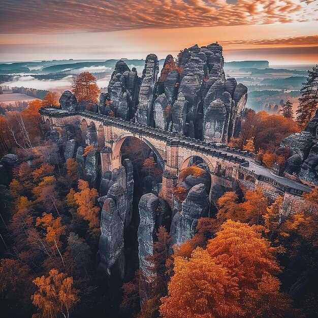
Plan a sunrise visit to the Swiss Alps to see the peaks glow with first light and photograph serrated silhouettes above pine slopes.
Then travel along Norway’s fjords, where long glacial arms reach toward the sea. A silencioso vessel cruise along the water reveals sheer rock faces and cascades that plunge into sheltered inlets.
In Croatia, Plitvice Lakes National Park presents layered terraces with turquoise pools linked by cascades, set among dense woods and a thriving avifauna along the paths.
Italy’s Dolomites and the Matterhorn offer alpine panoramas; pyramidal peaks rise above glacial valleys, inviting hikers to plan multi-day routes around high passes.
In Iceland, Gullfoss and nearby geothermal fields show a dynamic mix of ice and steam, while Vatnajökull holds vast ice that feeds rivers across the highlands.
Consejos prácticos: visit early, wear sturdy footwear, and allocate a couple of hours for each site to enjoy clear views and quiet moments.
Gouffre Berger, France: Practical Guide to Exploring Europe’s Deepest Cave
Plan your descent with a licensed guide; youll need a booking and a safety briefing before entering Gouffre Berger. Referred to as Europe’s deepest cave, Gouffre Berger in France’s Isère region offers a completely subterranean world where the interior unfolds through a sequence of shafts and dimly lit galleries. The surface approach is simple, but the exploration inside demands focus, steady rhythm, and respect for the cave’s delicate balance. The scenery above ground remains picturesque, with birds circling above the entrance as you prepare; the underground passages reveal a powerful, great contrast that leaves visitors marveling.
Gear list: helmet with secure chin strap; headlamp with two back-up sources; sturdy boots with grip; a durable harness and rope kit; warm, moisture-wicking layers; a waterproof shell; and a small pack with water and snacks. youll carry a spare light, batteries, and a compact first-aid kit inside. Guides handle fixed lines and anchors; do not improvise. With proper conditioning and rope techniques, the descent to the largest sections can take most of a day; pace yourself and listen to your guide.
The interior features dimly lit galleries, underground lakes, and the constant hum of running water. The route may require wading through shallow pools and careful footwork through slick rock. Falls create echoes that sharpen eyes and contribute to the sense of scale; the space feels powerful yet open and simple in some sections, while hiding complex passage networks elsewhere. Visitors should remain respectful of the environment, keep hands free for rope work, and listen to the guide’s instructions. For some, the textures on mineral formations evoke lascaux-like patterns, a curious link between prehistoric art and modern exploration; marveling at this contrast helps you feel how humans have used cave spaces across the ages.
Getting there: take a train to a nearby French town, then a short bus ride or taxi to the trailhead. A single day trip is common for experienced groups, but many visitors prefer an overnight stay in a nearby village to allow for a calm start and exit before fatigue sets in. The entrance is modest, but the descent below ground is anything but; plan for a full-day schedule, and respect the opening times and safety rules provided by your guide, because the cave is dynamic and weather-dependent. Local guides, including a veteran named lovech, help newcomers with pacing, rope handling, and how to read cave signs.
Location specifics: Gouffre Berger’s geographical setting and access route
Begin with a licensed guide and enter Gouffre Berger only with a full team and proper gear. Inside the limestone cavity, the initial chamber opens into a wide passage and a tall shaft, delivering a spectacle that echoes the drama of the Matterhorn. Just as you step in, keep your headlamp bright and your pace deliberate, and respect fixed lines and rope sections. Padirac and Aggtelek are renowned centers in their own right, but Gouffre Berger centers on technical cave exploration in a way that demands coordinated teamwork and careful planning.
Location specifics: Gouffre Berger sits inside the Vercors limestone massif, within the Isère region of central France. The entrance lies just below a cliff on the plateau’s edge, inside a wooded hillside that frames a karst valley. The cave’s network formed as groundwater flowed through carbonate rock, eroding and expanding passages since the earth cooled. The system includes a deep cavity and a series of canyons and chambers, making it a landmark in European speleology and a full experience for skilled cavers–ahead of other famous examples such as Krubera, Mulino, Altamira, or larger cave complexes that show different karst dynamics.
Access route: Begin at the plateau trailhead above the valley and park at the designated pull-off, then follow a marked path that climbs to a saddle. From there, a short scramble leads down to the entrance; plan a 30–60 minute approach depending on conditions. Enter via the cleft and descend into the main passages with a guide; rope gear is required for vertical sections, and a helmet is mandatory. The longest vertical segments in the network require careful ropework and teamwork. Always check weather before you go, as rainfall can raise water levels below. For a safe, memorable experience, coordinate with a local speleological club, respect the environment, and use the center of your plan to understand how the earth’s flow has shaped these caves for generations.
Access, permits, and booking: steps to arrange a visit
Book online through the official park authority at least six weeks before your visit to secure entry permits and a specific time slot.
In regions like vatnajokull, many routes in protected zones require a guide and a permit; verify the rule for your chosen path with local authorities. If your plan includes a steep descent, ensure the guide is qualified for glacier terrain.
Consult the primary source of information on the park’s site or the national tourism portal to confirm which forms to submit and where to send them.
Lead times vary by season; summer slots fill quickly, so plan six to eight weeks ahead and note group size limits (often 8–12 participants per guide).
Prepare documents and gear; bring government ID, the permit receipt, weather-appropriate clothing, durable boots, a basic first-aid kit, and sun protection. youll want to keep the load light.
On the day, arrive early for check-in, present permits, and listen to the guide’s safety briefing. During the descent or ascent, follow the path markers and respect closures in place where necessary.
If you travel from ireland or majorca, plan buffer days for transfers and consider packages that connect multiple sights; you can align your stay with nearby places and hostels for easy access to the next site. The route often offers powerful scenery and adrenaline moments, with picturesque views that highlight the beauty of the region.
For curious visitors, some routes pass near paleolithic sites and even vilenica cave histories; guides may share greek myths to enrich the experience while you observe rock forms along the gorge.
Seasonal timing and conditions: when to plan your descent
Plan your descent in late spring or early autumn for most sites to balance daylight, weather stability, and crowd levels. For vatnajokull and other glaciers, expect variable wind and rapid weather shifts; this window keeps temps manageable and allows longer sunlit days without mid-summer meltwater floods. If forecasts shift, continue to monitor and adjust plans instead of forcing a descent into a risky slot.
Across the continent, microclimates demand site-specific timing: verdon’s south-facing cliffs warm up fast, target April–June or September–October; lamprechtsofen caves stay accessible with guided slots; capri’s sea-cliff experiences shine in late spring and early autumn when seas calm and suns arc lower for dramatic light. millions of light beams cross crystal walls, making ethereal moments. In borgio, coastal routes respond to wind and tides; in basilicata, pollino trails offer better conditions in May–September; you can continue planning with local guides for maximum safety.
| Sitio | Best Window (months) | Approx Daylight | Key Conditions | Gear & Access |
|---|---|---|---|---|
| vatnajokull | Mid-June to early September | 14–20 hours peak; wind risk possible | Glacier routes, crevasses, cold temps | First gear: helmet, crampons, ice axe; rope, harness; warm layers; waterproof boots; access requires permit |
| verdon | April–June and Sept–Oct | 12–14 hours in spring; heat possible in summer | Rugged limestone, potential floods in spring, sun exposure | Helmet, sturdy boots, rope systems; access through local guides; caution on wet ledges |
| lamprechtsofen | March–October (tours run year-round with schedules) | 10–12 horas, dependiendo de la iluminación de la cueva | Formaciones cristalinas etéreas; temperatura constante de la cueva ~8–12 C | Casco, lámpara frontal, capas abrigadas; reservar visitas guiadas; registrarse en la oficina de la cueva. |
| borgio verezzi | April–June and Sept–Oct | 12–16 horas | Acantilados costeros orientados al sur; el viento y el estado del mar influyen en el descenso. | Arnés de escalada donde sea necesario; chaleco salvavidas para senderos costeros; acceso mediante permiso local. |
| capri | capri | 12–14 horas; condiciones del mar variables | Vistas de acantilados marinos, conexiones de ferry; la afluencia alcanza su punto máximo a mediados del verano | Kayak de mar o rutas de acantilados requieren guía; arnés ligero; protección solar |
| pollino, basilicata | Mayo–Septiembre | 11–15 horas; preferiblemente en estación seca | Senderos de montaña; el clima puede cambiar rápidamente; vida silvestre | Botas resistentes, bastones de trekking, mapas; permiso donde sea requerido; acceso a través de guardaparques locales. |
Equipo, entrenamiento y seguridad: consejos para la exploración de cuevas
Comprueba tu casco, tu linterna frontal y las baterías de repuesto antes de cada descenso; una fuente de luz fiable es crucial para los pasajes subterráneos que se revelan de maneras espectaculares.
En las secciones húmedas, prevea nadar a través de lagos acumulados; traiga una bolsa estanca para los dispositivos electrónicos, un traje de baño y una muda de ropa. Use calzado resistente con buena tracción y guarde calcetines de repuesto en una bolsa impermeable; lleve una toalla pequeña para secarse al salir a la superficie.
- Casco con una correa de barbilla segura y una opción de visera facial, si está disponible.
- Linterna frontal primaria más dos de repuesto; baterías impermeables y baterías extras
- Cuerda o línea fija adecuada para la vía; para principiantes, una longitud de 20–30 m cubre muchas verticales
- Botas de espeleología resistentes o botas de senderismo con buen agarre y protección para las rodillas
- Bolsas estancas para aparatos electrónicos, documentos y ropa adicional
- Capa cálida para cuevas invernales y una capa ligera para zonas de sensación térmica.
- Botiquín de primeros auxilios, silbato y un mapa impermeable o navegador sin conexión.
- Cinta métrica o cordel para calcular la anchura de los pasajes, las caídas y los puntos de anclaje
- Cinta de marcación o tiza para marcar tu camino y una pequeña libreta con notas
El entrenamiento debe ser práctico y progresivo. Tome un curso reconocido de seguridad en cuevas con un guía cualificado, realice comprobaciones con su compañero y acuerden señales, hora de regreso y procedimientos de emergencia. Practique primero en secciones secas, luego en áreas ligeramente húmedas y, finalmente, simule un descenso vertical bajo supervisión. Antes de comenzar, revise la ruta con su guía, confirme múltiples opciones de salida a lo largo de la ruta y establezca un presupuesto de tiempo realista para cada segmento. Crear un ritmo tranquilo le ayuda a gestionar la energía y mantener la concentración durante un largo día en la cueva.
La planificación estacional importa. En invierno, protéjase contra el agua fría y los cambios bruscos de temperatura; limite la exposición y planifique capas extra de abrigo. En verano, planifique la hidratación, la exposición al sol antes de entrar y controle la fatiga. Tenga siempre un plan en el que confíe plenamente; informe a sus compañeros de su plan y confírmelo con su guía. En Georgia y otras regiones kársticas, el clima afecta al acceso a las cuevas y a los niveles de agua; ajuste el equipo en consecuencia.
En lugares famosos, el contexto importa. Algunas cuevas se encuentran dentro de áreas catalogadas por la UNESCO, y las normas locales pueden exigir permisos o acceso guiado. En la costa de Carvoeiro, las cuevas marinas costeras exigen conocer las mareas y respetar la erosión; permanezca en los caminos marcados para evitar perturbar las delicadas formaciones. Cuevas como Lascaux nos recuerdan que es cautivadora a través del tiempo, con una geología poderosa y piedras espectaculares que atraen tanto a visitantes como a investigadores. En Georgia, diferentes entornos de cuevas invitan a la exploración con un guía experimentado que pueda medir los riesgos y proporcionar consejos de seguridad. De hecho, las cuevas conectan con antiguas historias humanas, haciendo de cada expedición a través del tiempo una experiencia significativa para los visitantes.
Lugares de interés cercanos e ideas para viajes: ampliando su itinerario europeo de cuevas
Empieza con la Cueva de Postojna, Eslovenia, para una introducción muy eficiente disponible aquí: un paseo guiado de algo más de 90 minutos a través de rocas calizas iluminadas que albergan millones de estalactitas y estalagmitas, seguido de un corto viaje en tren entre salas. El tiempo justo para saborear el contraste.
Después de esto, diríjase al sur, a Basilicata, para visitar las grutas de Pertosa-Auletta, donde un recorrido en barco de 60 minutos navega por un río a través de un sistema kárstico; las cámaras iluminadas revelan rocas en tonos tierra, mientras que las estalactitas cuelgan del techo como linternas.
En la misma región también puede visitar la cueva gigante (Grotta Gigante) para comparar escalas: una imponente cámara con columnas formadas a lo largo de millones de años, conectadas por amplios pasadizos y una atmósfera luminosa y bien iluminada.
A continuación, diríjase al norte, a Islandia, y explore las cuevas de hielo bajo Vatnajökull. Las paredes congeladas reflejan la luz del sol en facetas azules, y los guías le conducen a través de túneles iluminados durante 2 o 3 horas, destacando las formaciones de hielo más altas y el impresionante contraste entre tierra y hielo.
Francia ofrece el gouffre de Padirac, un abismo muy conocido donde un ascensor te deja caer al vacío y un barco se desliza a lo largo de un río subterráneo bajo rocas que relucen con una iluminación naranja y blanca. Esta parada combina bien con un día explorando las cuevas cercanas y la zona del Gouffre en la superficie.
Finalmente, incorpore una escapada a una isla griega al plan. La costa griega esconde cuevas marinas entre acantilados y calas isleñas; puede combinar ferries, cortos trayectos en barco y paseos en tierra para saborear la luz del sol sobre el agua y las formaciones kársticas que modelan tanto la costa como las cavernas.