

 Explore Tasmania’s Wild Natural Beauty – Untamed Landscapes, Coastlines & Trails">
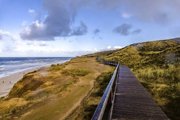
Start with Freycinet on Tasmania’s east coast, where a two-day loop reveals white-sand coves and rugged granite. Wineglass Bay Lookout rises above a sheltered cove, and the 11 km circuit to Hazards Beach finishes with fiery sunsets. The round-trip to the lookout runs about 2.5 hours, and the full circuit can take 4–5 hours depending on your pace and weather. This joylashuv offers a compact taste of coastal wilderness, with footprints that finish well before dark and leave space for a relaxed evening under the stars.
On. second day, switch inland to Cradle Mountain–Lake St Clair National Park, where alpine scenery and mossy forests anchor your plan. The Dove Lake Circuit is a ~6 km loop that typically takes 1.5–2 hours; a short detour to Marion’s Lookout adds 1–2 hours and a 360-degree vista that makes the pace worthwhile for all skill levels. A guided commentary can help identify tracks, optimize weather windows, and ensure you finish the day with confidence and energy.
The Bay of Fires coast adds another dimension: roughly 160 km of white-sand shores and turquoise water. The best months are late spring to early autumn for moderate crowds and clear seas. Plan a 2–4 hour coastal walk along exposed headlands and sheltered coves. Tower-like sea stacks punctuate the shoreline, and the light delivers dramatic photography opportunities each sunset. If you travel with friends, coordinate pickups to avoid long waits at remote access points, and let the commentary from local guides sharpen your observations of flora and seabirds.
In the Tasman Peninsula, long cliffs and sea stacks rise from the Southern Ocean. The Cape Pillar track delivers a day of rugged walking and culminates at a dramatic outcrop where three tower-shaped stacks push the skyline. Along the way you’ll pass large windswept shoulders, and you’ll spot bennetts wallabies grazing on tussock edges and wombats foraging at dusk. If you’re traveling with a husband or friends, split the load: one carries water and the map, the other handles layers and snacks for quick pauses on exposed sections.
Maria Island completes the loop with a car-free chapter that rewards slow exploration. A 39-minute ferry from Triabunna lands you at Darlington; from there, track networks lead to the Painted Cliffs and fossil-rich shorelines. Bennetts wallabies call the grassy slopes home, while wombats roam the old convict roads after lunch. The island is best done as a two-day escape; reserve ferry seats early because the timetable can drop during shoulder season and kuting. times vary. A concise joylashuv note: plan to return to the mainland for the last crossing and a final coastal glow over the water.
The future of Tasmanian wild country remains strong, and careful planning helps you avoid disappoint. If permit costs dropped last year or wait times shifted, keep a flexible itinerary and backup options. A solid map ensures you won’t miss a turn, and the right pace creates perfection in light and tide. When you travel with friends or a husband, build in rest periods so everyone finishes with energy and a smile, ready to share commentary on the day’s discoveries and to plan the next adventure without delay.
Practical Breakdown: Core Inclusions for Tasmanian Wildlands
First, book a guided option that directly covers the core inclusions with an organized, day-by-day plan. Think of this as a first-priority approach that keeps you on track across the whole-island areas and offers size-adjusted pacing for adults.
Inclusions you can count on include transportation between major areas, park permits or state access passes, and meals aligned with dietary needs. A transit pass or park pass is provided, and lodging or camping arrangements are organized to suit your group size. The evident advantage is predictable logistics and direct support from a guide.
Optional activities are clearly defined, with sunrise starts and flexible windows for side trails and short explorations along established routes. Expect sunrises seen from safe overlooks, and allow room to adjust along the day. This setup helps you tailor the program to the size of the party while staying within your pace.
For reliability, look for a confirmed trustindex score and direct support from a guide. This provides visitor assurance and a guarantee that emergency contacts, gear checklists, and safety briefings stay on your plan. The finding from recent reviews helps you compare options and choose with confidence.
Plan timing with the 23rd window and a broader july slot by checking tourville listings. Pick a program that includes dietary accommodations and optional upgrades, then compare state coverage and areas covered to ensure a coherent whole-island experience. Thanks for reading these tips; glad you’re preparing for a memorable Tasmanian wildlands visit.
Untamed Landscapes: Key Regions and What to See
Pick Cradle Mountain–Lake St Clair as your first stop to feel Tasmanian wild from the start. cosy lodges and a warm café scene welcome you after the drive. Do the Dove Lake circuit in the morning; it’s a short, scenic loop that takes about 1–2 hours and gives you the first glow of dolerite peaks reflected in still water. If you planned a longer stay, add the Mount Tasman or Lake St Clair tracks for a half-day option, but check the forecast and plan time to return before dusk.
Move east to Freycinet Peninsula for red granite, white coves, and the Wineglass Bay lookout. For a shorter option, the Hazards Beach Circuit covers about 11 km and a couple of hours with beach strolls. To keep a thoughtful pace, stay in Coles Bay and stretch meals across the day; you can pick online bookings for guided walks, or use Uber to reach trailheads from nearby towns. Planning an itinerary helps balance hikes with foods and rest; lunch could be fresh seafood bowls, and dinner may be as simple as a pesto pasta by the shore.
On the Bay of Fires, northeast Tassie’s long beaches and turquoise shallows invite relaxed days. Pick a base at Binalong Bay or St Helens and stroll the sands at low tide; for a longer day, drive toward Eddystone Point and explore coves and birdlife. Online maps help, but you can also book a guided kayak trip online. For meals, stop at local cafés for coffee and cheeses or sample smoked fish; bring extra money for a sunset drink before continuing your route.
To the northwest, the Tarkine belts a wild rainforest heart with the Arthur River and Montezuma Falls, one of Tasmania’s most striking waterfalls. Do the Montezuma track if you have a half day; otherwise a forest loop near the river gives you a sense of this remote corner. A thoughtful packing list–waterproof boots, wind shell, and a compact stove–lets you stay out longer. Staying in a nearby campground or caravan park keeps you close to breathtaking morning light; what you see depends on the weather, so have a flexible plan and a back-up option.
Southwest National Park hosts the wildest corners of the main island, with Mount Anne looming above lush moorland. A 5–6 day Overland Track segment offers a deep immersion with huts along the way; if you prefer shorter, choose day walks from well-placed bases and save energy for coastal sunsets. Plan carefully: book huts online and stock up on foods for a few days; late spring and autumn deliver the best light.
Two-week planning tips: start with Cradle Mountain, Freycinet, Tarkine, and Southwest; assign 2–3 nights each and a final rest in Hobart or Launceston. On the 12th you may be back near one of the cities, depending on your route. Staying options range from cosy cabins to eco-lodges, conveniently located near trails. Pick places with easy trail access, plan meals around markets, and keep money for occasional guided tours.
Coastlines & Beaches: Access Points, Best Viewing Spots, and Safety
Begin at Freycinet National Park, Coles Bay: park at the Freycinet Visitor Centre and start with Wineglass Bay Lookout. It’s a 1.0–1.5 hour return climb; for a total coastal day, continue along the Hazards Beach Circuit, a roughly 11 km loop that can take 4–5 hours at a comfortable pacing. The view across the coasts lets you feel nature in a close, physical way.
Bay of Fires offers long, sea-green coasts and an array of beaches. Access from Binalong Bay car park supports several short 1–2 hour loops that reveal bright water across headlands and bays. Best viewing spots sit along the headlands at sunrise or sunset when the light heightens color across the coast; pack a light meal to enjoy on the sand and pace yourself for wellbeing.
On the Tasman Peninsula, Fortescue Bay and the Cape Hauy Track deliver dramatic cliffs and the Totem Pole sea stack. The Cape Hauy Track forms a 4–6 hour circuit that climbs bluff edges and returns via the cliff path; ensure you stay on marked paths and heed weather warnings. This is a showcase across the wilds of the coast; you may see seals and seabirds.
Safety first: check park alerts and alarms for swell and closures before you go. Carry water (2–3 litres for a full day), sunscreen, a hat, sturdy boots, and a lightweight first-aid kit. Watch for sneaker waves at exposed beaches, and avoid narrow ledges during windy conditions. Tides can cut off access to some beaches; know your exit route and have a plan rather than standing in one spot. Let a friend know your plan and expected return time to avoid feeling stranded. spent a moment affirming your pacing, and you’ll keep the day seamless.
In Coles Bay or nearby township, choose a plan that balances nature with heritage and community. Local guides like caroline can tailor a circuit to your chosen pace, from a gentle coastal stroll to a demanding day of hiking. A hostel stay keeps costs down while you trade tips on the trails; many venues publish reviews that help you pick the right route. After a day on the coast, a meal at a seaside café offers a taste of local produce and a chance to debrief for wellbeing. Across varied shorelines, the light show and sea air shape your feel for the coast, and the story you bring back becomes a record of determination and growth so that you share it with bettereveryone. Let the shared moments spark making memories you’ll carry home to your hometown and beyond.
When you finish, review your route and note the seasons for the best light; Tasmania’s wilds reveal new colours across the coast each month, rewarding patience and careful planning with a high wellbeing return. This journey, crafted with care, demonstrates how a single circuit can grow into a longer exploration that doubles your appreciation for nature, culture, and the people who maintain these treasured places.
Trails & Hiking: Route Picks, Distances, Sunrise/Sunset Timing
Begin with Cradle Mountain’s Dove Lake Circuit: a 6 km loop that fits a 3–4 hour window and yields a fantastic sunrise glow over the water. Along the shore, echidnas roam, and mossy plants frame the lake; cosy shelters provide a quick rest. If cant spare a long day, this circuit still offers a memorable feel and a great testing ground for your planning and pacing. Orient your pace to your abilities; recently updated boardwalks help maintain footing, and this info verifies access times before dawn.
For a longer coastal option, Wineglass Bay Lookout + Hazards Beach Circuit runs about 11 km and takes 4–5 hours. Start before dawn to orient toward the sea and catch sunrise colors along the bay; the route includes stairs and boardwalks and offers memorable overlooks. The parking can require a dollar at busy car parks; consider a reservation for a shuttle if you travel in peak season. Includes plenty of flora and seabird activity, making it ideal for a slow, physical day with planning built in.
Cape Hauy Track, Freycinet coast, spans 3.5 km round trip with dolerite stacks along the cliff edge. Dawn or late afternoon light makes the sea stacks pop, so start times vary with season. This route fits a 2–3 hour rate and is great for families and couples–husband and wife often share the climb and a final coffee at the car park, along chants of waves and seabreeze. Leading viewpoints reward careful footing and patience.
Kunanyi/Mount Wellington choʻqqisiga olib boruvchi yoʻl taxminan 8–9 km boʻlib, jiddiy jismoniy zoʻriqishni talab qiladi. Xobartning oltin nurda uygʻonishini tomosha qilish uchun erta tongda yoʻlga chiqing; yoʻl granit zinapoyalar va qaragʻayli soʻqmoqlar boʻylab koʻtarilib, shaharning va dengizning keng manzaralarini taqdim etadi. Ob-havoni bilish va barqaror tezlikka rioya qilish sayohatni qulay qiladi; yoqimli yakun uchun tushgandan keyin Fern Tree yoki Xobartdagi kafega boring. Shamol va bulutlarga e'tibor bering va haroratning tez o'zgarishi uchun bir nechta kiyim qatlamini oling.
Rejalashtirish boʻyicha maslahatlar: quyosh chiqish vaqtlarini tekshiring, qirgʻoq boʻylab sayohat qismlari uchun suv qaytish vaqtlariga moslashing va xotirjam yakunlash uchun qoʻshimcha bir soat vaqt ajrating. Bunday yondashuv ularning qobiliyatlariga moslashishga yordam beradi va oila a'zolaringiz yoki do'stlaringiz bilan baham ko'rish uchun bir nechta unutilmas lahzalarni yaratadi. Bron qilishni tekshirish va parkning so'nggi yangiliklari kirish va xavfsizlik qoidalariga rioya etilishini tasdiqlaydi va sayohatning muammosiz o'tishini ta'minlaydi.
| Trail | Distance (km) | Type | Quyosh chiqishi/botishi vaqti | Eslatmalar |
|---|---|---|---|---|
| Dove Lake Circuit (Cradle Mountain) | 6 | circuit | Yozda eng yaxshi yorug'lik soat 6:30–7:30 da; qishda esa ertaroq | Oʻrtacha tezlik; qirgʻoq boʻylab yexidnalar; qirgʻoq boʻylab oʻsimliklar; mashinalar qoʻyish joyi bir dollarga tushishi mumkin |
| Wineglass Bay Lookout + Hazards Beach Circuit | 11 | circuit | Quyosh chiqishidan ~2 soat oldin Lookoutga boshlang; Xavf plaji bo'ylab quyosh botish variantlari | 4–5 soatlik narx; zinapoyalar va taxta yo'laklar; qirg'oq o'simliklarini o'z ichiga oladi; bron qilish parkovka gavjum paytida osonlashtirishi mumkin |
| Cape Hauy Track (Freycinet sohili) | 3.5 | borib-qaytish | Tong yoxud kunduzning oxirgi nuri | 2–3 soatlik tezlik; qoyali manzaralar; dolerit ustunlarining oldingi qismi; shamolga moyil qismlar bo'ylab |
| Kunanyi/Vellington tog'ining cho'qqisiga olib boruvchi yo'l | 8–9 | borib-qaytish | Hobart ustidan tong yorug'ligi; quyosh chiqishidan 1,5–3 soat oldin boshlang | Jismoniy ko'tarilish; zinapoyalar va granit; qulay kafeda yakunlash; rejalashtirish ob-havo qarorlariga yordam beradi |
Yovvoyi tabiat bilan uchrashuvlar: Hurmat va xavfsizlik bilan qayerda kuzatish kerak
Tasmaniya Parks and Wildlife Service tomonidan boshqariladigan parkda ranger boshchiligidagi sayrni tanlang va oldindan joy band qiling. Xaritada belgilangan yo'ldan boradigan aylanma yo'lakdan boshlang; bu butun yashash joyini va o'rmonning bir qismini himoya qiladi hamda odamlar uchun kunni xavfsizroq qiladi. Kuzatayotganda, haqiqiy ko'rinishlar ko'pincha juda sokin va sabrli bo'lganingizda kelishini unutmang, shunda siz o'sha lahzani o'tkazib yubormaysiz.
- Parklardagi belgilangan yo‘laklarda qoling; adashib yurish o‘simliklar va hayvonlar xatti-harakatlariga xalaqit berishi mumkin.
- Yovvoyi tabiatdan hurmatli masofada turing; yaqinlashish o'rniga durbin yoki kattalashtiruvchi ob'ektivdan foydalaning.
- Ovozingiz va harakatlaringizga e'tibor bering; agar mashina haydayotgan bo'lsangiz, yovvoyi tabiat yaqinida sekinlashtiring.
- Yovvoyi tabiatga teginish yoki ularni ovqatlantirish mumkin emas; hech qachon hayvonni ko'tarish yoki joyini o'zgartirishga urinmang.
- Sohillar va qirg'oq hududlarida o'ziga xos turlar yashaydi; ruxsat etilgan joylardan kuzating va hech qachon hayvonlar yo'llarini to'smang.
Qayerda kuzatish mumkin
- Gordon hududi, Gordon daryosi boʻylab va yaqin atrofdagi sohillarda, odatda dengiz qushlari va vallabilar shom paytida qirgʻoqqa chiqadi.
- Trent daryosi estuariysi yaqinidagi plyajlar, ayniqsa, tongda va shomda, qushlar juda katta to'dalarga to'planganda.
- Franklin-Gordon Wild Rivers milliy bog'i ichida, rejalashtiruvchilar va qo'riqchilar xavfsiz tomosha qilish uchun belgilagan o'rnatilgan aylanma yo'llarga ergashing.
Xavfsiz uchrashuvlar uchun amaliy maslahatlar
- Uzoqdan kuzating; agar bir lahzani o'tkazib yuborsangiz, xotirjam bo'ling va yovvoyi tabiatga xalaqit bermasdan davom etishiga ruxsat bering.
- Hayvonlarga stress bermaslik uchun fleshni o'chiring va ovozlarni past tuting.
- Moslashuvchan vaqt bilan kunlarni rejalashtiring, lekin yovvoyi tabiat haqiqiy namoyish uchun to'xtab qolsa, uzoqroq kutishga tayyor bo'ling.
- Yovvoyi tabiat onasi va bolasi bilan uchrashganda, ularga qo'shimcha joy kerak bo'ladi; ularga joy bering va sekin orqaga tising.
- O'zingizning aqliy va jismoniy holatingizga e'tiborli bo'ling; sabr-toqat ko'pincha eng ajoyib manzaralarni hech qanday aralashuvsiz taqdim etadi.
Manba va hisobot: Yangilanishlarning ishonchli manbasi uchun bog'lar xizmati saytini va mahalliy sayyohlik markazlarini tekshiring. Joriy kuzatuvlar va tegishli hisobotlarni topish kuningizni rejalashtirishga yordam beradi va kutilayotgan sharoitlarga mos keladi. Har doim rezervasyoningizni tayyor holda saqlang va xotira va yo'l-yo'riqning shaxsiy manbasi uchun topilmalaringiz haqida eslatmalar olib keling.
Ob-havo, Fasllar va Yuklash: Qachon Borish va Nima Olib Kelish
Ko'p qirrali qatlamli to'plamni o'rashing: suv o'tkazmaydigan qobiq, izolyatsiya qiluvchi o'rta qatlam, nafas oladigan asosiy qatlamlar va mustahkam sayohat etiklari. Tasmaniyaning ob-havosi shiddatli bo'lishi mumkin, bir zumda o'zgarib turadi, shuning uchun sizning jihozlaringiz quyosh, yomg'ir va shamolni ko'tarishiga amin bo'lishingiz kerak. Park va qirg'oq bo'ylab sayr qilish uchun ixcham yomg'ir qatlami, qo'shimcha paypoqlar va uzoq sayohatlarda qulay bo'lish uchun quyosh qalpoqchasini olib yuring. Sayohat sayohatlari uchun getrlar va shamol o'tkazmaydigan qatlamni qo'shing. Yo'llar sayohatchilarning keng doirasi uchun qulay, ammo shamol orolning umurtqasiga urilgandan so'ng sharoit tezda yomonlashishi mumkin.
Yoz (dekabr–fevral) juda uzun kunlar, okean shabadalari va qirg'oqda ishonchli iliqlikni olib keladi; odatda kunduzgi harorat 20–26°C, ichki hududlarda va balandlikda salqinroq, kechalari esa 12–16°C atrofida bo'ladi. Kuz (mart–may) asta-sekin sovib boradi, tiniq tonglar, ravshan manzaralar va kunduzgi harorat 14–22°C atrofida bo'lib, vaqti-vaqti bilan yomg'ir yog'ishi mumkin. Qish (iyun–avgust) haroratni pasaytiradi, ichki hududlarda tog'li bog'larda sovuq yoki qor bo'lishi mumkin; qirg'oq kunlari tez-tez yomg'ir bilan salqin bo'ladi. Bahor (sentabr–noyabr) quyosh va yomg'ir aralashmasini taklif etadi, kunduzgi harorat 12–20°C atrofida va shamollar keskin bo'lishi mumkin. Yaxshiroq ko'rinish va xavfsizroq yo'llarni kutganingizda erta yo'lga chiqing. Ular joylashuvga qarab farq qiladi.
Tabiat xilma-xilligi uchun yuk yig'ish: suv o'tkazmaydigan kurtka, iliq o'rta qatlam, termal paypoqlar, qo'lqoplar, shapka, mustahkam etiklar, quruq xalta va xaltangiz uchun ixcham yomg'ir qoplamasi. Quyoshdan himoya, hasharotlardan saqlovchi vosita, butilka yoki hidratatsiya tizimi, xarita yoki oflayn navigatsiya va kun oxirida kashfiyotlar uchun bosh chirog'ini olib keling. Shtat parklari — Cradle Mountaindan Franklin-Gordon Wild Riversgacha — turli xil hududlarni qamrab oladi, shuning uchun loyqa joylar uchun getralarni qo'shing. Piyoda sayr qilish marshrutlari uchun yengil kunduzgi xalta va kichik favqulodda vaziyatlar to'plami uchun joy ajrating. Kunduz kuni suv, dam olish va suratga olish uchun reja bilan jo'nab keting.
Rejalashtirish va xavfsizlik uchun kuningizni ishonchli ob-havo ma'lumotlari va hududning mikroiqlimiga moslashtiring. Agar haydovchi yollasangiz, marshrutingiz va mo'ljallangan vaqtlarni ulashing, shunda jadvalga rioya qilishingiz mumkin. Ular sizga olomon yig'ilishidan oldin ko'rishga arziydigan joylarga yetib borishingizga yordam beradi va ob-havo o'zgarishi bo'lsa, tezda moslashishingiz mumkin. Keyin, sozlamalar xilma-xilligidan bahramand bo'lish uchun qirg'oq yo’llarini o'rmon yo'llari bilan aralashtiring; Tasmaniya sayohatlari qiziqishni juda maxsus joylar bilan taqdirlaydi, xoh u ochiq qirg'oq chizig'i bo'lsin, xoh himoyalangan qirqquloqli o’rmonlar. Barqaror bo'lish uchun yuk xaltangiz rejasidan foydalaning, so'ngra ajoyib tabiat, mehribon mahalliy aholi va Tasmaniyaning qo'riqlanmagan hududlari haqida chuqurroq tushunchaga ega bo'lgan holda qaytib keling.