

 Истражите дивљу природну лепоту Тасманије – нетакнути пејзажи, обале и стазе">
Start with Freycinet on Tasmania’s east coast, where a two-day loop reveals white-sand coves and rugged granite. Wineglass Bay Lookout rises above a sheltered cove, and the 11 km circuit to Hazards Beach finishes with fiery sunsets. The round-trip to the lookout runs about 2.5 hours, and the full circuit can take 4–5 hours depending on your pace and weather. This локација offers a compact taste of coastal wilderness, with footprints that finish well before dark and leave space for a relaxed evening under the stars.
On the second day, switch inland to Cradle Mountain–Lake St Clair National Park, where alpine scenery and mossy forests anchor your plan. The Dove Lake Circuit is a ~6 km loop that typically takes 1.5–2 hours; a short detour to Marion’s Lookout adds 1–2 hours and a 360-degree vista that makes the pace worthwhile for all skill levels. A guided commentary can help identify tracks, optimize weather windows, and ensure you finish the day with confidence and energy.
The Bay of Fires coast adds another dimension: roughly 160 km of white-sand shores and turquoise water. The best months are late spring to early autumn for moderate crowds and clear seas. Plan a 2–4 hour coastal walk along exposed headlands and sheltered coves. Tower-like sea stacks punctuate the shoreline, and the light delivers dramatic photography opportunities each sunset. If you travel with friends, coordinate pickups to avoid long waits at remote access points, and let the commentary from local guides sharpen your observations of flora and seabirds.
In the Tasman Peninsula, long cliffs and sea stacks rise from the Southern Ocean. The Cape Pillar track delivers a day of rugged walking and culminates at a dramatic outcrop where three tower-shaped stacks push the skyline. Along the way you’ll pass large windswept shoulders, and you’ll spot bennetts wallabies grazing on tussock edges and wombats foraging at dusk. If you’re traveling with a husband or friends, split the load: one carries water and the map, the other handles layers and snacks for quick pauses on exposed sections.
Maria Island completes the loop with a car-free chapter that rewards slow exploration. A 39-minute ferry from Triabunna lands you at Darlington; from there, track networks lead to the Painted Cliffs and fossil-rich shorelines. Bennetts wallabies call the grassy slopes home, while wombats roam the old convict roads after lunch. The island is best done as a two-day escape; reserve ferry seats early because the timetable can drop during shoulder season and wait times vary. A concise локација note: plan to return to the mainland for the last crossing and a final coastal glow over the water.
The future of Tasmanian wild country remains strong, and careful planning helps you avoid disappoint. If permit costs dropped last year or wait times shifted, keep a flexible itinerary and backup options. A solid map ensures you won’t miss a turn, and the right pace creates perfection in light and tide. When you travel with friends or a husband, build in rest periods so everyone finishes with energy and a smile, ready to share commentary on the day’s discoveries and to plan the next adventure without delay.
Practical Breakdown: Core Inclusions for Tasmanian Wildlands
First, book a guided option that directly covers the core inclusions with an organized, day-by-day plan. Think of this as a first-priority approach that keeps you on track across the whole-island areas and offers size-adjusted pacing for adults.
Inclusions you can count on include transportation between major areas, park permits or state access passes, and meals aligned with dietary needs. A transit pass or park pass is provided, and lodging or camping arrangements are organized to suit your group size. The evident advantage is predictable logistics and direct support from a guide.
Optional activities are clearly defined, with sunrise starts and flexible windows for side trails and short explorations along established routes. Expect sunrises seen from safe overlooks, and allow room to adjust along the day. This setup helps you tailor the program to the size of the party while staying within your pace.
For reliability, look for a confirmed trustindex score and direct support from a guide. This provides visitor assurance and a guarantee that emergency contacts, gear checklists, and safety briefings stay on your plan. The finding from recent reviews helps you compare options and choose with confidence.
Plan timing with the 23rd window and a broader july slot by checking tourville listings. Pick a program that includes dietary accommodations and optional upgrades, then compare state coverage and areas covered to ensure a coherent whole-island experience. Thanks for reading these tips; glad you’re preparing for a memorable Tasmanian wildlands visit.
Untamed Landscapes: Key Regions and What to See
Pick Cradle Mountain–Lake St Clair as your first stop to feel Tasmanian wild from the start. cosy lodges and a warm café scene welcome you after the drive. Do the Dove Lake circuit in the morning; it’s a short, scenic loop that takes about 1–2 hours and gives you the first glow of dolerite peaks reflected in still water. If you planned a longer stay, add the Mount Tasman or Lake St Clair tracks for a half-day option, but check the forecast and plan time to return before dusk.
Move east to Freycinet Peninsula for red granite, white coves, and the Wineglass Bay lookout. For a shorter option, the Hazards Beach Circuit covers about 11 km and a couple of hours with beach strolls. To keep a thoughtful pace, stay in Coles Bay and stretch meals across the day; you can pick online bookings for guided walks, or use Uber to reach trailheads from nearby towns. Planning an itinerary helps balance hikes with foods and rest; lunch could be fresh seafood bowls, and dinner may be as simple as a pesto pasta by the shore.
On the Bay of Fires, northeast Tassie’s long beaches and turquoise shallows invite relaxed days. Pick a base at Binalong Bay or St Helens and stroll the sands at low tide; for a longer day, drive toward Eddystone Point and explore coves and birdlife. Online maps help, but you can also book a guided kayak trip online. For meals, stop at local cafés for coffee and cheeses or sample smoked fish; bring extra money for a sunset drink before continuing your route.
To the northwest, the Tarkine belts a wild rainforest heart with the Arthur River and Montezuma Falls, one of Tasmania’s most striking waterfalls. Do the Montezuma track if you have a half day; otherwise a forest loop near the river gives you a sense of this remote corner. A thoughtful packing list–waterproof boots, wind shell, and a compact stove–lets you stay out longer. Staying in a nearby campground or caravan park keeps you close to breathtaking morning light; what you see depends on the weather, so have a flexible plan and a back-up option.
Southwest National Park hosts the wildest corners of the main island, with Mount Anne looming above lush moorland. A 5–6 day Overland Track segment offers a deep immersion with huts along the way; if you prefer shorter, choose day walks from well-placed bases and save energy for coastal sunsets. Plan carefully: book huts online and stock up on foods for a few days; late spring and autumn deliver the best light.
Two-week planning tips: start with Cradle Mountain, Freycinet, Tarkine, and Southwest; assign 2–3 nights each and a final rest in Hobart or Launceston. On the 12th you may be back near one of the cities, depending on your route. Staying options range from cosy cabins to eco-lodges, conveniently located near trails. Pick places with easy trail access, plan meals around markets, and keep money for occasional guided tours.
Coastlines & Beaches: Access Points, Best Viewing Spots, and Safety
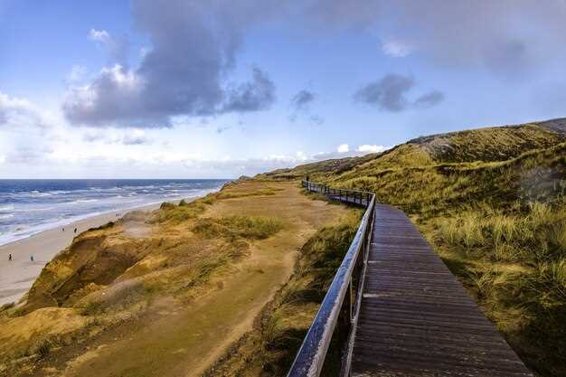
Begin at Freycinet National Park, Coles Bay: park at the Freycinet Visitor Centre and start with Wineglass Bay Lookout. It’s a 1.0–1.5 hour return climb; for a total coastal day, continue along the Hazards Beach Circuit, a roughly 11 km loop that can take 4–5 hours at a comfortable pacing. The view across the coasts lets you feel nature in a close, physical way.
Bay of Fires offers long, sea-green coasts and an array of beaches. Access from Binalong Bay car park supports several short 1–2 hour loops that reveal bright water across headlands and bays. Best viewing spots sit along the headlands at sunrise or sunset when the light heightens color across the coast; pack a light meal to enjoy on the sand and pace yourself for wellbeing.
On the Tasman Peninsula, Fortescue Bay and the Cape Hauy Track deliver dramatic cliffs and the Totem Pole sea stack. The Cape Hauy Track forms a 4–6 hour circuit that climbs bluff edges and returns via the cliff path; ensure you stay on marked paths and heed weather warnings. This is a showcase across the wilds of the coast; you may see seals and seabirds.
Safety first: check park alerts and alarms for swell and closures before you go. Carry water (2–3 litres for a full day), sunscreen, a hat, sturdy boots, and a lightweight first-aid kit. Watch for sneaker waves at exposed beaches, and avoid narrow ledges during windy conditions. Tides can cut off access to some beaches; know your exit route and have a plan rather than standing in one spot. Let a friend know your plan and expected return time to avoid feeling stranded. spent a moment affirming your pacing, and you’ll keep the day seamless.
In Coles Bay or nearby township, choose a plan that balances nature with heritage and community. Local guides like caroline can tailor a circuit to your chosen pace, from a gentle coastal stroll to a demanding day of hiking. A hostel stay keeps costs down while you trade tips on the trails; many venues publish reviews that help you pick the right route. After a day on the coast, a meal at a seaside café offers a taste of local produce and a chance to debrief for wellbeing. Across varied shorelines, the light show and sea air shape your feel for the coast, and the story you bring back becomes a record of determination and growth so that you share it with bettereveryone. Let the shared moments spark making memories you’ll carry home to your hometown and beyond.
When you finish, review your route and note the seasons for the best light; Tasmania’s wilds reveal new colours across the coast each month, rewarding patience and careful planning with a high wellbeing return. This journey, crafted with care, demonstrates how a single circuit can grow into a longer exploration that doubles your appreciation for nature, culture, and the people who maintain these treasured places.
Trails & Hiking: Route Picks, Distances, Sunrise/Sunset Timing
Begin with Cradle Mountain’s Dove Lake Circuit: a 6 km loop that fits a 3–4 hour window and yields a fantastic sunrise glow over the water. Along the shore, echidnas roam, and mossy plants frame the lake; cosy shelters provide a quick rest. If cant spare a long day, this circuit still offers a memorable feel and a great testing ground for your planning and pacing. Orient your pace to your abilities; recently updated boardwalks help maintain footing, and this info verifies access times before dawn.
За дужу приобалну опцију, видиковац залива Вајнглас + стаза плаже Хазардс је дуга око 11 км и траје 4–5 сати. Крените пре свитања да се окренете према мору и ухватите боје изласка сунца дуж залива; рута укључује степенице и шеталишта и нуди незаборавне погледе. Паркинг може захтевати долар на прометним паркиралиштима; размислите о резервацији шатла ако путујете у шпици сезоне. Укључује мноштво флоре и активности морских птица, што га чини идеалним за спор, физички дан уз планирање.
Staza Cape Hauy, obala Freycinet, proteže se 3,5 km u oba smera sa naslagama dolerita duž ivice litice. Svetlost u zoru ili kasno popodne čini da se stene u moru ističu, tako da vreme polaska varira u zavisnosti od sezone. Ova ruta odgovara tempu od 2–3 sata i odlična je za porodice i parove–muž i žena često zajedno dele uspon i ispijaju poslednju kafu na parkingu, uz zvuke talasa i morskog povetarca. Vodeće tačke gledišta nagrađuju pažljiv korak i strpljenje.
Staza na vrhu Kunanyi/Mount Wellington obuhvata 8–9 km u oba pravca sa zahtevnim fizičkim usponom. Krenite pre zore da biste videli Hobart kako se budi u zlatnoj svetlosti; staza se penje granitnim stepenicama i borovim jarugama, nudeći širok pogled na grad i more. Poznavanje vremenskih prilika i stabilan tempo čine uspon prijatnim; za udoban završetak, nakon spuštanja idite u kafić u Fern Triju ili Hobartu. Ne zaboravite da se orijentišete prema vetru i oblacima i ponesite slojevitu odeću zbog naglih promena temperature.
Saveti za planiranje: proverite vreme izlaska sunca, planirajte oko plime i oseke za obalske deonice i ostavite sat vremena rezerve za opušten završetak. Ovaj pristup vam pomaže da se uskladite sa njihovim sposobnostima i stvara nekoliko nezaboravnih trenutaka koje možete podeliti sa porodicom ili prijateljima. Provere rezervacija i ažurna obaveštenja parka potvrđuju pristup i smernice za bezbednost, obezbeđujući nesmetan izlazak.
| Trail | Растојање (km) | Тип | Време изласка/заласка сунца | Белешке |
|---|---|---|---|---|
| Кружна стаза око језера Дав (Планина Крејдл) | 6 | circuit | Najbolje svetlo: 6:30–7:30 ujutru leti; ranije zimi | Умерен темпо; јехидне уз обалу; биљке дуж обала; паркинг може коштати долар. |
| Видековац залива Вајнглас + кружна стаза плаже Хазардс | 11 | circuit | Крените ~2 сата пре изласка сунца за Видиковац; опције за залазак сунца дуж плаже Хазардс. | 4–5 сати; степенице и шеталишта; укључује приморске биљке; резервација може олакшати паркирање током шпица |
| Стаза Кејп Хои (обала Фрејсине) | 3.5 | повратно | Zora ili svetlost kasnog popodneva | 2–3 сата; погледи са литица; водећа ивица наслага долерита; дуж делова изложених ветру |
| Врх Кунањи/планине Велингтон | 8–9 | повратно | Сумрак над Хобартом; почетак 1,5–3 сата пре изласка сунца | Физички успон; степенице и гранит; удобан кафић на крају; планирање помаже у одлукама у вези са временом |
Сусрети са дивљим животињама: Где посматрати са поштовањем и безбедно
Одаберите шетњу са водичем-ренџером у парку којим управља Служба за паркове и дивље животиње Тасманије и резервишите унапред. Крените стазом у облику петље која вас држи на мапираној стази; ово штити читаво станиште и део шуме и чини дан безбеднијим за људе. Када посматрате, запамтите да се права опажања често дешавају када останете веома тихи и стрпљиви, како не бисте пропустили тренутак.
- Držite se obeleženih staza u parkovima; skretanje sa njih može poremetiti biljni i životinjski svet.
- Држите се на безбедној удаљености од дивљих животиња; уместо да се приближавате, користите двоглед или зум објектив.
- Pazi na buku i kretanje; ako voziš, uspori kada si blizu divljih životinja.
- Не смете додиривати нити хранити дивље животиње; никада не покушавајте да подигнете или преместите животињу.
- Plaže i priobalna područja su staništa posebnih vrsta; posmatrajte sa dozvoljenih vidikovaca i nikada ne blokirajte životinjske puteve.
Где посматрати
- Област Гордона дуж реке Гордон и оближњих плажа, где морске птице и валабији често долазе на обалу у сумрак.
- Плаже у близини естуара реке Трент, посебно у зору и сумрак када се птице окупљају у огромним јатима.
- У оквиру Националног парка Франклин-Гордон Вилд Риверс, пратите успостављене кругове које планери и ренџери обележавају за безбедно разгледање.
Praktični saveti za bezbedne susrete
- Posmatrajte iz daljine; ako propustite trenutak, ostanite mirni i pustite životinje da nastave bez ometanja.
- Искључите блиц и говорите тихим гласом како не бисте узнемирили животиње.
- Планирајте дане са флексибилним временом, али будите спремни на дуже чекање ако дивље животиње застану за прави приказ.
- Susret sa divljim životinjama, majkom i mladuncima, zahteva dodatni prostor; dajte im prostora i polako se udaljite.
- Будите свесни свог менталног и физичког стања; стрпљење често доноси најблиставије погледе без уплитања.
Izvor i nalog: Za pouzdan izvor informacija, proverite sajt Službe parkova i lokalne centre za posetioce. Pronalaženje aktuelnih viđenja i povezanih naloga pomaže u planiranju dana i usklađuje se sa očekivanim uslovima. Uvek imajte pri ruci rezervaciju i ponesite beleške o svojim nalazima kao lični izvor sećanja i smernica.
Време, годишња доба и паковање: Када ићи и шта понети
Spakujte svestran slojeviti komplet: vodootpornu jaknu, izolacioni srednji sloj, prozračne osnovne slojeve i čvrste planinarske čizme. Tasmanijska klima ume biti žestoka, menja se u trenutku, tako da morate biti sigurni da vaša oprema podnosi sunce, kišu i vetar. Za šetnje po parkovima i obali, ponesite kompaktnu kabanicu, dodatne čarape i šešir za sunce da biste se osećali udobno tokom dugih šetnji. Za planinarske izlete dodajte kamašne i sloj otporan na vetar. Staze su pristupačne širokom krugu planinara, ali uslovi mogu brzo da se pogoršaju kada vetar udari u kičmu ostrva.
Leto (decembar–februar) donosi veoma duge dane, okeanski povetarac i pouzdanu toplinu duž obale; tipičan dnevni raspon je obično 20–26°C, hladnije u unutrašnjosti i na većoj nadmorskoj visini, sa noćima oko 12–16°C. Jesen (mart–maj) se postepeno hladi, sa svežim jutrima, jasnim pogledima i dnevnim rasponom oko 14–22°C uz povremene pljuskove. Zima (jun–avgust) snižava temperature, u unutrašnjim zonama može biti mraza ili snega u alpskim parkovima; obalni dani ostaju hladni sa čestim kišama. Proleće (septembar–novembar) nudi mešavinu sunca i pljuskova, dnevni raspon oko 12–20°C, i vetrove koji mogu biti oštri. Krenite rano kada očekujete bolju vidljivost i sigurnije staze. One se razlikuju u zavisnosti od lokacije.
Spakujte za različitost prirode: vodootpornu jaknu, topli srednji sloj, termo čarape, rukavice, kapu, čvrste čizme, vodootpornu vreću i kompaktnu navlaku za kišu za ranac. Ponesite zaštitu od sunca, repelent protiv insekata, flašu ili sistem za hidrataciju, mapu ili navigaciju van mreže i naglavnu lampu za istraživanja u kasnim popodnevnim satima. Državni parkovi – od planine Cradle do reka Franklin-Gordon Wild Rivers – pokrivaju raznolik teren, pa uključite kamašne za blatnjave deonice. Za planinarenje/pešačke itinerere, rezervišite prostor za lagani dnevni ranac i mali komplet za hitne slučajeve. Krenite sa danjim svetlom i planom za vodu, odmor i trenutke za fotografisanje.
За планирање и безбедност, усмерите свој дан према поузданој прогнози и микроклими локације. Ако унајмите возача, поделите своју руту и циљана времена како бисте остали у распореду. Они вам помажу да стигнете до места са обавезним видиковцима пре него што се створи гужва и можете брзо да се прилагодите ако се време промени. Затим, помешајте приобалне стазе са шумским рутама да бисте уживали у распону окружења; путовања по Тасманији награђују радозналост врло посебним местима дуж изложених обала и заклоњених папратних пропланака. Искористите садржај свог плана паковања да останете стабилни, а затим се вратите са успоменама на изузетне природе, љубазне мештане и дубљи осећај нетакнутих региона Тасманије.