


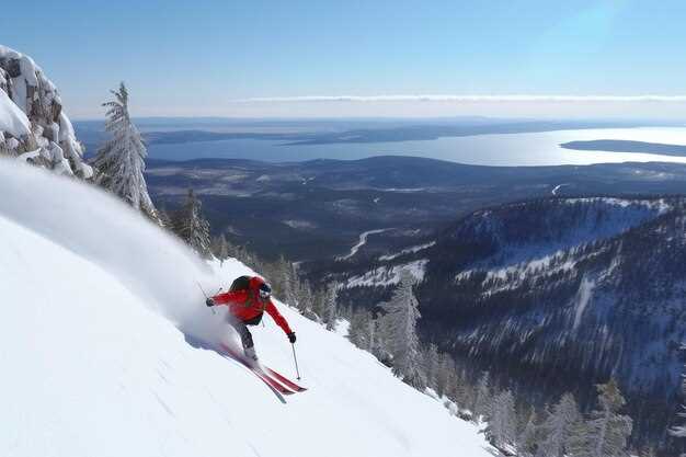
У самом срцу Тасманије, култна планина Крејдл стоји као доказ сирове лепоте природе и изазовног терена. Док сам планирао своју авантуру, схватио сам да ово неће бити само скијашки излет, већ експедиција која захтева пажљиво планирање и снажну посвећеност безбедности. У сарадњи са различитим тимовима и организацијама, осмислили смо сваки детаљ потребан да бисмо осигурали успешан спуст, имајући у виду јединствене карактеристике овог националног парка. Било је неопходно унапредити наше припреме са фокусом на аутохтоне земље које окружују то подручје, стварајући мрежу подршке која би користила свима укљученима.
На дан планираног спуштања, осетио сам бујицу емоција – узбуђење помешано са нервозом, онај осећај који обузима младе авантуристе када стоје на ивици непознатог. Наш пројекат је био амбициозан; спремали смо се да се спустимо на терен који је видео безбројне истраживаче пре нас, али нико није скијао у његовом пуном обиму. Ветар је шибао око нас, подсећајући нас на огромну снагу природе, али смо били одлучни да наше жеље супротставимо њеној сили. Настојали смо не само да остваримо личне циљеве, већ и да инспиришемо друге да се упусте у сопствена путовања кроз непознате територије.
Са сваким окретом и резбарењем по блиставом снегу, подсећао сам се на важност историје и повезанст са земљом. Свако спуштање низ планину није био само индивидуални подвиг, већ колективно сећање које ће временом бити преплављено, постајући део заоставштине планине Крејдл. Бележећи ову авантуру у дигиталном облику, желели смо да створимо трајни наратив који ће приказати лепоту и изазов овог величанственог места, истовремено подстичући будуће авантуристе да се одговорно и с поштовањем односе према природи. Док сам прелазио висораван, знао сам да проживљавам тренутак који ће одјекнути, не само у мојим сећањима, већ и у животима оних који ће кренути нашим стопама.
Мапирање пута: Разумевање слојева мапе
При припреми за експедицију попут првог потпуног скијашког спуста низ планину Cradle Mountain, разумевање различитих доступних слојева мапе је пресудно. Ове мапе често пружају кључне податке који помажу у навигацији сложеним теренима, као што су стрми јарузи и кулоари, омогућавајући авантуристима да ефикасно планирају своју руту.
Mape nisu samo puke karte; one pričaju priče o regionima koje pokrivaju. Na prvi pogled, može se videti oblik i dizajn planina, dolina i zamršeni obrasci regionalne topografije. Korišćenjem različitih slojeva informacija, možemo bolje razumeti pejzaž i locirati najbolje staze za našu avanturu.
Један ефикасан начин за навигацију кроз ове податке јесте путем апликације која омогућава додавање више слојева. Ови слојеви могу да укључују топографске информације, војне руте, па чак и планове веслања за оближње воде. Приступ таквим ресурсима је доступан из неколико извора, укључујући универзитетске пројекте који су страствени у истраживању природе.
| Тип слоја карте | Функције | Доступне информације |
|---|---|---|
| Topografske karte | Помоћ у лоцирању надморске висине и облика терена | Контуре, јаруге и стрме падине |
| Војне карте | Обезбедите детаљне информације о границама и стратегији. | Приступни правци и тактичке предности |
| Regionalne karte | Прикажи укупне карактеристике пејзажа и пловних путева | Rute za veslanje i rekreacione zone |
У припреми за путовање, лако је залутати без одговарајућих мапа. Упоређивањем белешки и секвенци на разним мапама, истраживачи могу да направе јасан план. Било да је то кроз дигитални интерфејс или физичке копије, прави ресурси могу да осигурају да је сваки корак путовања пажљиво испланиран.
Mape ne samo da poboljšavaju navigaciju već i omogućavaju bogato iskustvo pripovedanja. Svako brdo i dolina drže deo istorije tog područja, i kroz ova vizuelna pomagala, možemo se dotaknuti bogatih narativa koji okružuju planinu Cradle. Kao što smo naučili, mapiranje našeg putovanja ne samo da podržava našu fizičku navigaciju već nas i povezuje sa suštinom divljine koju smo toliko strastveni da istražujemo.
Шта су слојеви мапе и њихов значај у скијању?
Slojevi mape su ključni alati za navigaciju raznovrsnim terenima na skijanju, posebno kada se savladavaju zahtevne lokacije kao što je Cradle Mountain. Ovi slojevi pružaju vredne uvide koji pomažu skijašima da donesu informisane odluke o svojim rutama i bezbednosti.
На први поглед, слојеви мапе стварају свеобухватан алат за скијаше, омогућавајући им да се пребацују између различитих типова информација. Ево неколико важних аспеката слојева мапе у скијању:
- Topografske karte: Ове мапе приказују стрмину и контуре терена, што је кључно за мерење нагиба и идентификовање најбољих рута за спуштање. Скијаши могу брзо да процене која подручја могу захтевати напредне вештине или посебну опрему.
- Временски слојеви: Pristup vremenskim podacima u realnom vremenu omogućava skijašima da prate uslove, uključujući količinu snežnih padavina i promene temperature. Ove informacije su od vitalnog značaja prilikom planiranja skijaške avanture, posebno u zemlji kao što je Australija, gde se uslovi mogu brzo promeniti.
- Подаци о висини снега: Slojevi mape mogu da sadrže indikatore dubine snega, što pomaže skijašima da razumeju gde se može naći svež sneg. Ovo pomaže da se lociraju najbolja područja za spuštanje i uzbudljivo iskustvo.
- Sigurne zone: Означене локације попут подручја склоних лавинама и војних зона за обуку пружају кључне информације, осигуравајући да су скијаши свесни потенцијалних опасности док се крећу тереном.
- Мреже путева: Mape ilustruju regionalne mreže ski staza, omogućavajući skijašima da efikasno planiraju svoje rute, olakšavajući im da se vrate ili istraže nove staze, dok ostaju unutar dobro definisanih krugova.
Поред тога, дигиталне мапе могу бити згодан водич у непознатим регионима, пружајући детаљне приказе терена. Могућност зумирања повећава знање скијаша о пејзажима и помаже у доношењу практичних одлука о томе где скијати или се поново окупити са пријатељима.
Ови алати су такође у складу са иницијативама заједнице, као што су програми које организују локална скијашка друштва у циљу промовисања здравља и безбедности у зимским спортовима. Информације из издања скијашких часописа могу се интегрисати у слојеве мапа како би скијаши били у току са најновијим достигнућима у скијашкој технологији и техникама.
У закључку, акумулација ових дигиталних слојева мапа значајно унапређује скијашко искуство, пружајући дубину и контекст који обогаћују свако путовање низ падине. Од првог Јакобовог потпуног скијашког спуста на планини Крејдл до свакодневних скијашких рутина, вредност добро развијених мапа не може се преценити.
Врсте слојева мапа за скијашке авантуре
Приликом припреме за скијашку авантуру, разумевање типова слојева мапе који су доступни је кључно за успех. Различите мапе могу да вам помогну да: навигирати različitim terenima и помоћи у доношењу информисаних одлука током вашег путовања. Обично, ови слојеви укључују топографске карте, сателитске снимке и мреже стаза, а све дизајниран да би пружили увид у окружења са којима ћете се сусрести.
Топографске карте имају јединствен скала, приказујући промене надморске висине и стрмину стаза. Ово shape Познавање терена је од виталног значаја за проналажење најпогоднијих скијашких рута и избегавање опасних подручја. Са јасним ознакама за врхове и долине, топографске карте су од суштинског значаја за сваког ко скија на непознатом терену. Када имате копије од ових мапа, можете лако find праве путеве који одговарају вашим потребама.
Satelitski snimci pružaju drugačiju perspektivu, omogućavajući vam da glance на терену одозго. Овај слој може да открије тренутне услове, као што су покривеност снегом и утицај ветра, што значајно утицај your skiing experience. By reviewing recent images, you can better evaluate the suitability of locations and adjust your plans accordingly.
Trail networks are another major resource for skiing adventures. These maps showcase established routes and their капацитет for skiers, including easy and challenging trails. Knowing the distance of each trail helps in planning your outings, ensuring you don’t overextend yourself or your group. Trail maps often come with смернице that indicate the requirements necessary for safe skiing.
Utilizing these various map layers дозвољава skiers to engage in an impactful way, ensuring a fulfilling experience. With resources available through local institutes, you can gather the necessary information to feel срећан and confident while exploring. For those страствен about skiing, investing time in learning about these tools can significantly enhance your adventures.
In conclusion, having a solid understanding of map layers will help you effectively navigate the challenges of skiing in Tasmania’s beautiful landscapes. Don’t hesitate to reach out for additional подршка in mastering these skills and ensuring a successful skiing trip.
How to Choose the Right Map Layer for Cradle Mountain
Selecting the appropriate map layer for Cradle Mountain is crucial for a successful ski descent. There are various map layers available, each offering distinct features that cater to different requirements of adventurers. For a winter expedition, an aerial map may provide you with the best overview of the landscape, highlighting essential points like couloirs and plateaus that are often noted in adventure magazines.
Begin by evaluating your needs. If you want precise measurements for planning your route, opt for a topographic map layer. This type allows you to zoom in on specific locations and gain insights into the elevation changes you’ll encounter, essential for understanding the mountain’s terrain. On the other hand, if you are looking for a broader view with engaging features, an open map displaying the southern extent of Cradle Mountain’s landscape is an optimal choice.
As you measure your options, consider the support offered by different map layers. Some may provide winter weather details, while others focus on the health of the land and ecosystem. This is particularly beneficial when you’re looking to understand what conditions you’ll face during your descent. You might want to circle back and review different layers to ensure you’re not missing any vital information.
Additionally, using a toolkit that includes both print and digital formats will help you compare layers effectively. Physical copies can be instrumental when offline, while digital versions allow for dynamic viewing as you can adjust layers on-the-go. This dual approach solidifies your understanding of the terrain.
For young adventurers or those inexperienced, choosing a user-friendly map layer that incorporates colors and chains can make navigation easier. It’s essential to know how each layer presents data; a cluttered design may complicate decision-making. At a glance, you should be able to discern which features are most relevant to your desired route.
In conclusion, the best map layer for skiing at Cradle Mountain is one tailored to your adventure’s specific parameters, offering a combination of precise measurements, engaging features, and supportive insights. By doing your research and understanding the tools available, you elevate your experience and enhance the success of your ski descent.
Using Map Layers to Plan Your Route Effectively
Planning your ski descent on Cradle Mountain involves understanding the various map layers available to you. With the right tools, you can evaluate different terrains and find the optimal route for your adventure. In this case, accessing high-quality topographic maps is essential for your planning.
First, you’ll want to begin by opening these maps to understand the extents of the land you’ll be navigating. Many digital platforms provide map layers that show detailed elevations, trails, and points of interest. There, you can easily click through different editions to compare how the terrain changes in various seasons.
The three primary layers to consider include topographic, satellite, and zoning maps. Topographic layers will highlight the mountain’s plateau and identify steep drops or flat areas. Satellite images provide a real-world view, allowing you to visualize your route, while zoning maps help in understanding specific regulations or access rights to the land.
While planning, it’s also crucial to incorporate wellbeing aspects into your journey. By understanding the land and possible climate variations, you ensure a positive experience for you and your supporting teams. Make use of community forums or online platforms for sharing tips and insights on your planned route. This type of collaboration can enhance your outcomes.
As you put together your adventure, remember to apply guidelines provided by local institutes or ski societies. These resources often contain valuable information that helps refine your strategy. If you find it easy to navigate these tools, you’ll likely finish with a well-thought-out plan that enables you to tackle the mountain confidently.
In summary, effective route planning is a multi-faceted process. By accessing various map layers and utilizing supporting networks, you not only enhance your skiing experience but also foster a sense of community among enthusiastic outdoor adventurers like yourself.
Integrating Technology: Apps for Layered Mapping
In the adventure of the first full ski descent of Cradle Mountain, understanding the terrain is crucial. Technology has made significant strides that aid adventurers like myself in navigating these vertical landscapes. By leveraging layered mapping applications, you can access detailed maps that cover various aspects of the environment, including elevation, weather patterns, and snow accumulations.
These applications integrate data from multiple sources, providing a comprehensive view of the areas you want to explore. For instance, using apps like Landgate, you can examine boundary lines and gauge the geographical shape of the land before making your descent. You’ll also find records of previous descents, which can help ensure a safe and successful venture.
Community organisations and university research teams have collaborated to enhance these technologies. The outcome is tools that not only present images of the terrain but also allow users to interactively query features such as gullies and slopes that are often challenging to visualize on traditional maps.
As I prepared for this journey, the app provided a detailed rack of data points, including a number of routes explored by others. The integration of real-time weather updates and user-generated content made it easier to make informed decisions about where to paddle my way through the snow-covered landscape.
On the day of the descent, I begrudgingly accepted that while technology could not replace the thrill of the ride, it certainly added a layer of safety and understanding that you simply cannot overlook. Each time I descended into a new area, I felt a reckoning between technology and nature, a circle of trust established between my instincts and the measurements displayed on my device.
As an adventurer in this culturally rich Shire, I found it essential to ask questions about the land’s past and how these technologies can shape our understanding of such places. The apps serve not only as tools for navigation but also as gateways to further appreciate the natural beauty and history of the landscapes I rode down, connecting the experiences of today with those of the French explorers who first set their eyes upon these majestic mountains.
Real-life Example: My Experience with Map Layers on the Descent
During my adventure skiing down Cradle Mountain, I extensively utilized various map layers to ensure a successful descent. Before embarking on the journey, I noted the importance of having access to detailed maps, which included weather data, track specifications, and cultural points of interest. These layers proved essential for identifying the safest and most scenic routes.
While preparing, I turned to a free application that allowed me to explore different map sequences. The ability to toggle between layers made it easier to visualize the terrain. I verified the data with local agencies, which are passionate about maintaining accurate and up-to-date information. It was reassuring to know that I was using intelligently curated maps that reflected government recommendations and healthway guidelines.
On the descent, I encountered some heavy snowfall, which altered the landscape significantly. Here, the detailed charts I had printed really came into play. I remember begrudgingly pulling out my map while skiing, wishing I could focus solely on the experience. However, my commitment to the journey drove me to stay informed of my location. As I moved south towards the more elusive tracks, I appreciated the layers that defined specific subdivisions and features of the mountain.
In one case, I had to make a decision at a track fork. My mobile application indicated two potential routes. One took the central path that promised smoother skiing, while the other was less defined and likely to be more challenging. Thanks to the map details, I opted for the more social path, which would allow me to encounter fellow skiers along the way. This choice granted a sense of community, a feeling I valued immensely during my adventure.
Successfully accessing and interpreting the maps meant that I could fully immerse myself in the skiing experience without worrying about getting lost. The additional video functions within the app provided tips on proper skiing techniques for challenging sections, helping me remain in shape and focused throughout the day. By the end of my descent, I felt happy with my navigation choices, proud of having rode the slopes with confidence.
This experience firmly established my belief in the significance of map layers. As someone who appreciates outdoor adventures, I can’t emphasize enough how critical they are for culturally immersive and safe skiing experiences. Whether you’re an experienced skier or just starting, investing time in understanding map layers can profoundly impact your journey.