

 Annapurna Base Camp Trek – Végső útmutató és a látogatás legjobb időszaka">

The best time to trek ABC starts in October to early November: clear skies, stable temperatures, and a dry trail season create the royal backdrop you want for unforgettable mountain views.
A címről Pokhara, drive to Nayapul and begin a steady ascent through rhododendron forests and terraced villages, a route that spread your views across the valley and toward the snow-capped giants above.
The trek covers roughly 60–70 km round-trip over about 12 nap, and having a solid plan helps you pace safely to the highest point at 4130 m at Annapurna Base Camp, offering a classic Nepal experience for seasoned hikers and first-time high-altitude trekkers alike.
This trek is physically demanding, so stay ahead with proper training and nutrition in the weeks before starting. Plan a rest day around Chomrong; for those new to high elevations, remember that acclimatization matters. You must take it slow, drink plenty of water, and listen to your body. That feeling of accomplishment after reaching ABC is worth the effort.
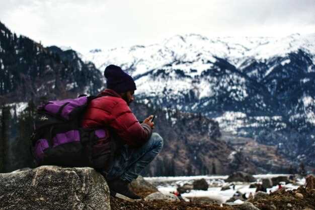
Temperatures vary by altitude and season; in lower elevations expect 15–25°C during the day, cooling to single digits at night. At base camp, nights can dip below freezing in autumn and winter, so layering is needed–bring a warm layer, a down jacket, and a waterproof shell to protect you in all conditions.
Ajánlott felszerelés includes layered clothing, sturdy trekking boots, a rain shell, a compact sleeping bag, and trekking poles. The period from post-monsoon to winter demands moisture protection and windproof gear to keep you comfortable after long days on the trail.
If you want a compact plan, remember that Pokhara remains a hub for rest days and travel connections; those who prefer a shorter option can enjoy lower-valley hikes, yet the true reward is the base camp panorama and sunrise over Machhapuchhre and Annapurna I.
Practical Planning for Annapurna Base Camp Trek
Plan at least one acclimatization day on the route to ABC to reduce altitude risk and maintain strength during this period.
Before you depart, secure the required permits: Annapurna Conservation Area Permit and TIMS card, and arrange a round trip flight from Kathmandu to Pokhara. Kathmandu, the capital, acts as your global logistics hub, while local communities along the trail host you in teahouses and service crews at modest prices.
Timing is decisive. The main trekking seasons typically run from March to May and late September to November, offering drier trails and clearer views. Across altitude, temperature ranges require proper layering; allow 2–3 extra days as a cushion to absorb weather changes and to explore must-see sites along the way, including waterfalls; you’ll meet communities of trekkers from around the global networks.
Pack a proper, layered kit that covers the core needs: breathable base layers, a warm mid-layer, a wind shell, sturdy boots, and a -10°C sleeping bag. Use tested gear and carry a compact repair kit; bring trekking poles for stability and to reduce fatigue. For water, purify or boil, and keep 2–3 liters available; pack fruit snacks for quick energy between meals and during the expedition. This approach helps you prepare for altitude changes and long days.
Plan a realistic day-by-day pace with 5–7 hours of trekking per day and 6–12 km per day, depending on terrain. A round pace helps you quickly adjust if fatigue rises and helps limit exposure to high-altitude stress. Include a major acclimatization stop at mid-route and reserve time for a must-do side detour to viewpoints to see the best views here. Once you reach ABC, enjoy the dramatic panorama of the main peaks, then stay a night to recover and soak the atmosphere away from crowds.
Stay in locally owned teahouses, tip guides and porters fairly, and respect local customs. Carry waste back to minimize impact, and use established trails and sites to protect fragile ecosystems. The strength of this route comes from the communities you meet along the way here, so give them your support and connect with fellow trekkers from the global network–this is where memories are built and future expedition starts.
Best Time to Visit Annapurna Base Camp: Month-by-Month Guide
October offers the clearest skies, warm days, and reliable trail conditions for the Annapurna Base Camp trek.
January brings cold, clear mornings and crisp air. Daytime temperatures in the lower area hover around 8–12 C; nights dip below freezing, and higher parts near sinuwa can see light snow. The hike to machhapuchhre viewpoints remains doable with proper first-aid and warm luggage; trails stay uneven in spots, so pace yourself early in the day, and consider extra rest days in shared lodges near boudhanath before continuing up the valley with a local guide.
February loosens the chill with longer daylight and quieter trails. Daytime temps in the lower areas stay around 10–15 C; nights still drop below freezing at higher elevations, and some sections are icy in the morning, making careful ascent and descent essential. Pack light, but include extra layers and a compact first-aid kit; many trekkers fly into Kathmandu, then ride to Pokhara with a local guide, so consider visa on arrival if your nationality allows it.
March brings warmer days and blooming rhododendrons, creating magnificent scenery along the area. Daytime temps rise to 12–18 C in lower valleys; higher passes stay cooler, so bring a wind layer for mornings. Local guides provide updated weather and route details, and you can book permits in advance to secure your start from boudhanath or a nearby town.
April delivers comfortable daytime temps (15–20 C) and vibrant flora along the route. The trail provides excellent visibility, and you will rise from sinuwa toward Deurali; expect larger crowds and reserve lodges ahead, especially for shared rooms; bring enough money and plan to protect luggage from humidity as you cross exposed areas near hiunchuli and machhapuchhre views.
May keeps the warm spell into mid-month, with mornings dry and days reaching 20–28 C in the lower area; higher sections cool. Crowds rise as trekking season peaks, so secure lodges ahead; be ready for occasional pre-monsoon showers that can make uneven trails slick and demand more time for ascents and travel between parts of the route.
June marks the start of the monsoon with heavy rain and humidity, especially in the lower area. Trails become muddy and some routes experience landslides, affecting ascents from sinuwa to abc; carry waterproof luggage covers, take extra protection for gear, and expect longer detours that require more money for changing plans.
July stays in full monsoon; trails stay slippery and clouded; hiunchuli and surrounding peaks may stay hidden, reducing visibility. Allow extra days for protection against rain, and consider a rest day in a local village; pakistan trekkers often adapt by splitting the trek with a Kathmandu visit to reduce exposure to weather risk.
August continues rain, though some higher parts get clearer mid-month as monsoon shifts; lower trails stay muddy, while the environment greens up and wildlife becomes active. If you press ahead, hike early, use maps, and keep your luggage safe in shared teahouse rooms; guides provide flexible schedules and contingency options.
September restores dry conditions and clear air. Take an early start for long hikes, as temperatures in the lower valleys range 18–22 C and higher passes stay cool; views of machhapuchhre and hiunchuli are outstanding. Being aware of dew in the mornings and uneven steps helps you pace safely between parts of the track.
October remains the prime window, a well-known choice among trekkers, with magnificent skies and long daylight. Day temps in lower areas 15–20 C, nights cool but manageable; above 3,000 m pack layers and sleep gear; secure permits and a visa ahead of time, and start from boudhanath area with a reliable local guide who provides up-to-date conditions. Expect busy trail sections near sinuwa and the base camp area, with hikers sharing lodges and meals.
November mirrors October with stable weather and crisp evenings. Day temps 12–18 C in the day and 0–5 C at night; visibility stays high for views of machhapuchhre, hiunchuli, and the surrounding area. Book early for accommodation and plan extra money for potential transfer delays or weather shifts; this month is well suited for serious hikes and extended ascents to viewpoints.
December brings solitude but cold nights; days stay clear, but temperatures drop sharply after sunset. In lower regions, daytime temps hover around 6–12 C, while high elevations stay near or below freezing; carry heavy luggage protection and multi-layer clothing; the environment remains pristine, and the skies stay brilliant for photography near boudhanath when you circle back.
Weather, Terrain, and Day-by-Day Trek Pace Across Seasons
Plan autumn (late Sept–Nov) for dry, reliable conditions, or spring (Mar–May) for moderate temperatures and blooming valleys. Hire an experienced, friendly guide who can tailor each day’s pace to your group and help you take a steady, safe tempo.
Weather and terrain vary by season. Autumn brings clear skies and comfortable days, with daytime highs around 15–20°C at lower elevations and nights near 5–10°C; high passes remain crisp but manageable. Spring mirrors autumn in clarity, with added warmth during afternoons and lush valleys along the lamjung regions. Monsoon (summer) floods trails with humidity, rain, and slick surfaces, increasing risk on exposed sections near waterfalls; winter delivers cold mornings, possible snow at higher altitudes, and slower progress as trails firm up in frost. In all seasons you’ll encounter dense forests, rhododendron groves, stone steps, and long descents that demand careful footing and breathing control.
Terrain shifts from shaded forest to open ridges, where walking sticks, breathable layers, and sleeves matter. Expect steep ascents, occasional rock ledges, and gradual descents toward terraced villages. The route includes must-see viewpoints, cultivated terraces, and remote stretches where the air lightens by the third hour before lunch. In wet months, water seepage and muddy stretches test traction, so tested footwear and a dry bag keep your meals, snacks, and meal gear ready. The highest point sits near the Annapurna Sanctuary at about 4130m, and you’ll descend toward comfortable tea houses as you head back toward lower lands.
Day-by-day pace across seasons keeps a steady rhythm. In autumn and spring, most days run 4–6 hours of walking at moderate elevation, with optional short excursions to viewpoints. During monsoon, add 1–2 hours for cautious steps and river crossings; in winter, mornings feel slower but afternoons warm to a comfortable level. Regardless, a round-trip rhythm helps you conserve energy for the final approach to the base camp, where you should receive a short rest before the ascent to the high meadow. Your guide will adjust the pace so your team stays together, with extra time for photos at captivating scenes and must-see sweepers along the topography.
Typical day-by-day pace (season-aware): Day 1: Nayapul to Tikhedhunga – 4–5 hours (autumn/spring); 5–7 hours (monsoon); 5–6 hours (winter). Day 2: Tikhedhunga to Ghorepani – 5–7 hours (autumn/spring); 6–8 hours (monsoon); 5–7 hours (winter). Day 3: Ghorepani to Poon Hill and Tadapani – 6–7 hours (autumn/spring); 7–9 hours (monsoon); 6–8 hours (winter). Day 4: Tadapani to Chomrong – 5–6 hours (autumn/spring); 6–7 hours (monsoon); 5–6 hours (winter). Day 5: Chomrong to Dovan via Sinuwa – 6–7 hours (autumn/spring); 7–8 hours (monsoon); 6–7 hours (winter). Day 6: Dovan to ABC – 5–6 hours (autumn/spring); 6–7 hours (monsoon); 5–6 hours (winter). Day 7: ABC to Bamboo – 3–5 hours (autumn/spring); 4–6 hours (monsoon); 4–5 hours (winter). Day 8: Bamboo to Jhinu Danda – 4–5 hours (autumn/spring); 5–6 hours (monsoon); 4–5 hours (winter). Day 9: Jhinu Danda to Nayapul – 4–5 hours (autumn/spring); 4–6 hours (monsoon); 4–5 hours (winter).
Section of safety and support. Carry first-aid essentials, a compact headlamp, and a layered kit to adapt to the heading shifts between warm afternoons and cool mornings. Wear moisture-wicking layers, a breathable shell, and a spare sleeve or two; keep a small dry bag for a change of clothes and a preferred snack. Guides can arrange reliable emergency contacts and, if needed, ensure you’re rescued quickly with local support. Camps and lodges along Lamjung’s routes offer friendly meals and tested, simple meals; you’ll receive hot tea, dal bhat, and a quick snack to keep you moving. A budget-minded traveler can expect tea houses with clean bedding and a basic meal for a comfortable, safe stay, while still enjoying the captivating, ever-changing views between forests and high meadows.
Section notes on regions and logistics. The Lamjung corridor connects to surrounding regions with varied terrain and village life, offering a calm pace and supportive crews. A dedicated guide team helps you take breaks when needed, ensuring you stay rested and ready for the next climb. First-aid, food, and shelter arrangements are standard; you’ll find dependable lodges at each stop, and most distances between villages are within the reach of a mid-range budget. During peak seasons, book early to secure rooms, meals, and a reliable route that prevents delays or scrambling for space. The route is designed so you can descend safely on the final days, while still meeting the must-see experiences that draw visitors to this captivating region.
Permits, Fees, and the Undertaking Form: What You Need to Know

Get the ACAP permit ahead of time from the Nepal Tourism Board offices in Kathmandu or Pokhara, or have your trekking operator arrange it for you. Please note the fee: 3,000 NPR per foreigner; TIMS, if required by your route, is about 2,000 NPR. Permits can be obtained at entry points or via your guide, and processing typically takes 15–25 minutes. Bring your passport, two photos, and exact cash; ensure the name on the permit matches your passport. If your package includes a guide, your operator handles these steps; irrespective of your plan, confirm the documents you need a week before leaving. Welcome to a smooth start for your ABC trek.
The Undertaking Form accompanies the permit. When you sign, you acknowledge altitude effects, weather shifts, and that you will follow marked routes and use permitted trails. The form states that rescue or evacuation costs fall on you or your group; there is no separate fee for the form itself. Provide contact details and a copy of your passport; your guide can help with the submission, and you should keep a digital copy on your page as a backup.
Where to submit: ACAP desks in Kathmandu, Pokhara, or at gateway towns along the ABC route. Typical access points include Besisahar and Nayapul; sinuwa and chhomrung are common stops on the trail, with hille sections above the village trails. Your operator usually keeps copies for your group and ensures you have the Undertaking Form with the ACAP permit. For the ABC route, you may need to present your passport, two photos, and your TIMS (if applicable).
Practical planning: Start early in the day to catch daytime viewpoints and avoid crowds; carry a simple meal plan and a reliable water bottle; choose village stays with good quality meals to maintain energy during altitude changes. Expect scenic trails, capped ridges, and breathtaking views of Himchuli and surrounding massif peaks. The information on permits and the Undertaking Form helps you hike with confidence, and your guide will explain each detail using clear language; this approach keeps you together with your group and respecting local culture.
Kell-e Esetleg Vállalási Nyilatkozatot Benyújtanom? Lépések, Követelmények és Tippek
Igen. A túra megkezdése előtt nyilatkozatot kell benyújtanod, különösen, ha Csomrongba és más Himalája környéki falvakba látogatsz el. A nyomtatvány biztosítja, hogy betartsd a hivatali szabályokat és a ellenőrzőpontok hálózatát, gondoskodva arról, hogy rendelkezz elsősegély-készültséggel és terved legyen a változó időjárásra, miközben az aranyló napfelkelte helyszínei és a közös táborok között mozogsz.
Íme a követendő folyamat, gyakorlati tippekkel a biztonság megőrzéséhez és a papírmunka egyszerűsítéséhez.
| Lépés | What to do |
|---|---|
| 1. Dokumentumok összegyűjtése | Gyűjtsön személyazonosító igazolványt, igazolványképet, orvosi igazolást, biztosítási kötvényt és vészhelyzeti kontaktokat. Készítsen másolatokat és gondoskodjon az eredetik beszerzéséről, ahol szükséges, különösen az iroda és az ellenőrzőpontok számára. |
| 2. Információk előkészítése | Adja meg személyes adatait, egészségügyi előtörténetét és a tervezett útvonalat. Jegyezze fel a Chhomrung környéki helyszínek és más hágók kockázatait; említse meg az esetleges elsősegély-képzést, ha van. |
| 3. Nyújtsa be az irodába | A Vállalási Nyilatkozatot adja le a helyi túrairodában vagy itt a központi irodában. Beszkennelt másolatát feltöltheti a hivatalos oldalra a repülőjáratok előtt vagy érkezéskor. |
| 4. Visszajelzés fogadása | Szerezzen be egy nyugtát vagy visszaigazoló kódot. Mentse el; lehet, hogy be kell mutatnia az ellenőrzőpontnál és az akklimatizációs megállóknál a csúcsokkal körülvett falvakban. |
| 5. Tartson magánál másolatokat | Tartson magánál egy kinyomtatott vagy digitális másolatot; gondoskodjon róla, hogy valaki a hálózatában hozzáférjen, ha elveszítené. Tartsa a dokumentumot az engedélyével és a vásárlási bizonylatokkal együtt, hogy gyorsan kéznél legyen. |
Az alábbi lépések betartásával felszerelt és kész maradhat, és elősegítheti az irodai folyamatok zökkenőmentes lebonyolítását. Fontolja meg valami egyszerű dolgot: egyetlen konszolidált oldalt a kapcsolattartási adataival, orvosi adataival és útvonaltervével, valamint egy biztonsági másolatot online tárolva itt az e-mailjében vagy a felhőben. A folyamat összekapcsolja Önt egy olyan hálózattal, amely a terep és az időjárás világait öleli fel, így védett marad, akár egy távoli chhomrung helyszíncsoporthoz, akár egy forgalmas ellenőrzőponthoz érkezik a főút közelében.
Tippek, hogy hatékonyan eligazodhass a vállalkozási űrlapon: vigyél magaddal egy kompakt nadrágot és egy rövidnadrágot a nagy magasságban való kényelem érdekében, valamint napszemüveget a hó visszaverődő fénye ellen. Ha további felszerelést kell vásárolnod, tedd meg indulás előtt, hogy elkerüld a késéseket az irodákban vagy ellenőrző pontokon. Üdvözlünk egy biztonságosabb túrán, amely felkészülten tart, miközben felfedezed a Himalája falvait és rizstermesztő völgyeit. Tartsd ezt az oldalt kéznél referenciaként, és ne feledd, hogy a pontos követelmények tételenként és szezononként eltérhetnek, ezért indulás előtt érdeklődj az irodában.
Nélkülözhetetlen felszerelés és csomagolási lista az ABC Trekhez
Csomagolj egy kompakt, réteges rendszert, amely egyensúlyban tartja a meleget, az eső elleni védelmet és a fejlámpa láthatóságát a himalájai területre; ez a beállítás reményt ad a túra befejezésére, és a fő csomag súlya 6-7 kg körül marad, egy kisebb hátizsákkal a túra ösvényein töltött percekre.
- Nagy hátizsák és kisebb hátizsák
- 40–45 literes hátizsák párnázott csípőövvel; használj esővédőt, és tartsd egyensúlyban a súlyt a fáradtság csökkentése érdekében.
- 10–15 literes hátizsák harapnivalóknak, fényképezőgépnek és egy könnyű rétegnek; csak szükség esetén tervezzük a használatát.
- Címkézze fel és lássa el a poggyászát a nevével és elérhetőségével, hogy vészhelyzet esetén gyorsan azonosítható legyen.
- Öltözködés és rétegezés
- Alaprétegek: 2 szett nedvességelvezető felső és 2 pár alsó; kerülje a pamutot.
- Középső réteg: polár vagy könnyű pehelykabát; személyenként egy.
- Külső réteg: vízálló, lélegző kabát és nadrág; biztosítson minőségi anyagokat, amelyek teljesítenek esőben és szélben.
- Túranadrág: 2 pár; egy átalakítható nappalra/éjszakára; a magasabb hágókhoz egy melegebb polárnadrág.
- Kiegészítők: sapka, meleg kesztyűk, nyakmelegítő; vastag zokni 3–4 pár és aláöltöző zokni.
- Lábbeli és lábápolás
- Egy pár jól illeszkedő, magas szárú túrabakancs; indulás előtt járasd be.
- Tartalék szandál vagy papucs az esti teaházakhoz.
- Vízhólyag-készlet: bőrkezelő tapasz, ragasztószalag, gézlap, kidörzsölődés elleni balzsam; hordjon magával nedvességmegkötő port.
- Hálózsákok és menedék
- 4 évszakos hálózsák -5°C és -10°C közötti hőmérsékletre tervezve; válasszon kompakt méretűre csomagolható hálózsákot.
- Bélés a nagyobb melegért és higiéniáért; használjon egy kis száraz zsákot az azonosítók és engedélyek gyors bemutatásra kész állapotban tartásához.
- Hidratálás, étel és tisztítás
- Vizespalackok vagy 1–2 literes víztasak; vigyél magaddal vízfertőtlenítő tablettákat vagy egy könnyű vízszűrőt.
- Elektrolitpor és magas energiatartalmú snackek; tervezzen 300–600 kcal-t a napközbeni szünetekre.
- A tűzhely opcionális; a legtöbb teaház ételt biztosít; vigyen magával egy könnyű bögrét és kanalat.
- Navigáció, biztonság és egészség
- Fejlámpa tartalék elemekkel; hozz magaddal papírtérképet és iránytűt az elektronika tartalékaként.
- Elsősegély készlet: hólyagkezelő, fertőtlenítő, géz, ragtapasz, fájdalomcsillapítók; ha a vezetőd javasolja, tegyél bele magashegyi betegségre vonatkozó készítményeket is.
- Napvédelem: SPF 50+ naptej, ajakbalzsam; tartson magánál egy kis elsősegély csomagot a kitett gerinceken eltöltött UV-s percekhez.
- Elektronika, dokumentumok és gondozás
- Power bank 10 000–20 000 mAh; fontolja meg egy kompakt napelemes töltő használatát a városok közötti hosszabb szakaszokon.
- Fényképezőgép vagy telefon, plusz memóriakártya; vízálló tok; extra akkumulátorok és SD kártyák.
- Útlevél, TIMS és ACAP engedélyek; másolatok külön tárolva; elérhetőségek és vészhelyzeti információk.
- Higiéniai termékek: biológiailag lebomló szappan, fogkefe, fogkrém, minimális törölközők, naptej; csomagold egy kis tasakba a könnyű hozzáférés érdekében az elkövetkezendő napokban.
- Utazástervezés és tippek
- A legközelebbi városok a túraútvonalak mentén vendégházaknak adnak otthont, ahol megszállhat; tervezze meg a pihenőket az idegenvezető céggel, és foglaljon előre a fittség és a kényelem megőrzése érdekében.
- Az utazás gyakran egy delhi repülőjárattal kezdődik; intézze el korán a nepáli belépési formaságokat, és hangolja össze a helyi engedélyekkel és a kiindulópontjával.
- Gondold át az eredeti felszerelésválasztásodat; a minőségi darabok tovább tartanak és csökkentik a felszerelés útközbeni cseréjének szükségességét.
- Élvezd a Himalája gazdagságát úgy, hogy a táskád könnyebb marad; a kisebb, jól megválasztott holmik jobban fognak szolgálni, mint a terjedelmes felszerelés.
- Mielőtt elindulsz, teszteld a teljes felszerelésedet pár perc otthoni tevékenységgel, hogy megbizonyosodj arról, hogy mindennek van értelmes helye és láthatóan, könnyen hozzáférhetően van elhelyezve a túra során.
- Ez segítene tartani a tempót, miközben gondoskodik a vendég túrázókról és vendégeikről, és megmutatja, hogy világos terve van a kényelmükre és biztonságukra a főbb ösvényeken.