


Komme im Morgengrauen an und fahre in den Big Bend, bevor die Hitze steigt. Wer mit dem Auto kam, weiß, dass das erste Licht über den prächtigen Kalksteinmauern unerreicht ist. Dein Plan sollte einfach sein: eine kurze, malerische Schleife, die dich in Bewegung hält und aus der Sonne bringt, besonders entlang der Flussschluchten, wo Hasen den Pfad kreuzen und die Luft kühler bleibt als in den offenen Ebenen. Wenn du nicht früh starten kannst, plane eine Session am späten Nachmittag, um trotzdem Farbe auf den Felsen einzufangen.
Der Park erstreckt sich über vielfältige Landschaften aus Wüste, Fluss und Canyon, wobei gewaltige Kalksteinwände jeden Aussichtspunkt prägen. Von den Städten im Landesinneren bis zum Rand verläuft Ihre Route durch einen Korridor, der entlang des Rio Grande verläuft und zwei Bundesstaaten berührt. Er bietet Farben und Strukturen, die sich mit jeder Höhenänderung verändern, besonders wenn Sie bei Sonnenuntergang die Canyonwände erreichen.
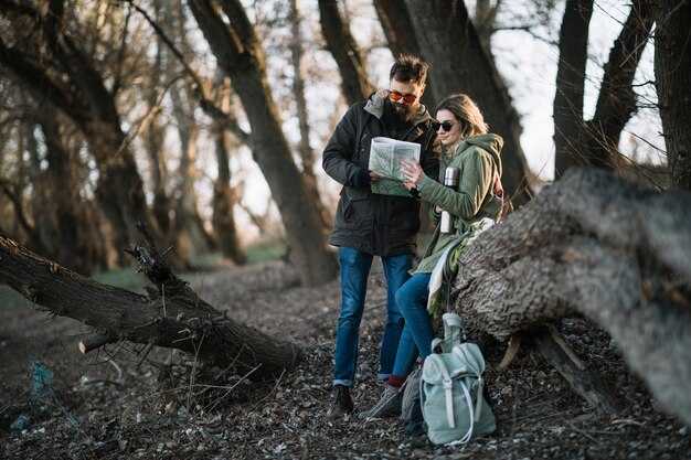
Plane eine Mischung aus kürzeren und längeren Wanderungen, um Hitze und Höhenunterschied auszugleichen. Der Lost Mine Trail ist etwa 7,7 km lang (Hin- und Rückweg), während die Route durch den Santa Elena Canyon dem Fluss über ein paar Kilometer folgt und ein gleichmäßiges Tempo belohnt. Achte auf Jackrabbits, die die offenen Ebenen überqueren, und bleibe während der heißesten Stunden auf schattigen Routen. Wenn du einen Pass überquerst oder ein Felsband erklimmst, verlangsame dein Tempo und halte dich an den Steinmännchen.
Hydrierung rettet Leben: Trinken Sie regelmäßig, nicht nur, wenn Sie Durst haben. Die Temperaturen im Big Bend können im Sommer 100 °F übersteigen; planen Sie für geringe Luftfeuchtigkeit und hohe UV-Strahlung. Packen Sie Wasser, Sonnencreme, einen Hut und eine leichte, langärmlige Schicht ein. Ein Maxwell-Tempo beibehalten.–langsam in der Hitze, bedächtig im Schatten und schnell, wenn Sie Wasser oder ein zuverlässiges Signal erreichen. Sie können sich ohnehin nicht auf einen einzigen Pfad oder Tag verlassen; überprüfen Sie Parkwarnungen, bevor Sie losgehen, und passen Sie die Pläne an Wetter und Sperrungen an.
Für das Campen im Hinterland ist eine Genehmigung erforderlich. Planen Sie im Voraus, denn die Plätze entlang des Rio Grande und im Hochbecken bieten eine ausgezeichnete Möglichkeit zur Sternenbeobachtung, aber Sie müssen Wasser und einen kompakten Kocher zum Kochen mitnehmen. Wenn Sie einen Meilenstein feiern möchten, besuchen Sie auf dem Rückweg eine lokale Brauerei und verwenden Sie die Flaschen wieder – hinterlassen Sie keinen Müll und halten Sie die Gegend sauber.
Vermeiden Sie für die Logistik Wochenenden in beliebten Monaten; Shuttle-Services sind begrenzt, planen Sie also, mit Ihrem eigenen Fahrzeug zu fahren. Wenn Sie von weit her kommen, planen Sie mehrere hundert Meilen ein und ziehen Sie eine Übernachtung in Midland oder einer nahegelegenen Stadt in Betracht, um die Fahrt zu unterbrechen; dies reduziert die Müdigkeit und hilft Ihnen, Ihre Energie für den Park zu sparen. Bringen Sie eine kompakte Karte und eine Ersatzbatterie mit und planen Sie, in den Besucherzentren Panther Junction oder Persimmon Gap anzuhalten, um Ihren Plan mit aktuellen Bedingungen und Schließungen zu aktualisieren.
Der ultimative Guide für einen Besuch des Big Bend Nationalparks
Reserviere Campingplätze sechs Monate im Voraus, besonders für Frühling und Herbst. Im Big Bend Nationalpark sind die Plätze im Chisos Basin und Rio Grande Village schnell ausgebucht, also lege Termine fest und überprüfe das Reservierungssystem des Parks. Es gibt eine Mischung aus einfachen und erschlossenen Optionen, von Wasser und Toiletten bis hin zu einfachen Zeltplätzen.
Plane von Antonio aus eine ganztägige Fahrt zum westlichen Tor und beginne dann mit Schatten und einer kühlen Brise. Beginne in den heißesten Monaten Wanderungen vor 9 Uhr morgens und pausiere mittags für Wasser und Schatten. Die Temperaturen können im Juli 35–40 °C erreichen, trage also mindestens einen Gallone (4 Liter) Wasser pro Person und Tag mit dir.
Die Unterkünfte reichen von komfortablen Lodge-Zimmern bis hin zu abgelegenen Campingplätzen; für einen entspannten Abend sollten Sie einen Aufenthalt in der Gegend von Terlingua und Margaritas nach Ihrer Wanderung in Betracht ziehen. Informieren Sie sich über Reservierungen in der Chisos Basin Lodge, im Rio Grande Village Resort oder auf nahe gelegenen Ranches; Unterkünfte finden Sie überall entlang des westlichen Randes.
Zu den landschaftlichen Höhepunkten gehören der Santa Elena Canyon, das Window und der Ross Maxwell Scenic Drive, wo sich der Himmel weit erstreckt und die Farben der Wüste sich bei Sonnenaufgang und Sonnenuntergang verändern. Bringen Sie einen guten Hut für die Sonne mit und packen Sie ein kompaktes Teleskop für sternenklare Nächte ein. Die Erfahrung bietet ein einzigartiges Gefühl der Einsamkeit, das den Park abgelegen erscheinen lässt.
Dinosaurier-Fußabdrücke und Fossilienreste deuten auf uraltes Leben in der Region hin; von Rangern geleitete Programme erklären den Kontext, und Sie werden Gesteinsschichten sehen, die Millionen von Jahre aufzeichnen.
Das WLAN im Park ist begrenzt. Plane daher, dich auf Offline-Karten, tragbare Ladegeräte und gedruckte Reiseführer zu verlassen. Einige Unterkünfte außerhalb des Parks bieten WLAN an. Informiere dich daher im Voraus und berücksichtige dies bei deiner Planung.
Internationale Besucher sollten gültige Reisedokumente mit sich führen, wenn sie Tagesausflüge zum Boquillas Canyon planen, wo möglicherweise Einreisebestimmungen gelten. Terlingua und die Chihuahua-Wüste ziehen Outdoor-Enthusiasten aus aller Welt an, mit geführten Wanderungen und Flussfahrten.
Wenn Sie Ihren Tag mit dem Blick auf den Sonnenaufgang beginnen, das Wetter checken und Schichten packen, hilft Ihnen das, sicher zu bleiben. Deshalb funktioniert in der Regel eine gemischte Reiseroute, die Campingplätze mit kleineren Unterkünften verbindet, unabhängig davon, ob Sie sich für eine Lodge oder ein Zelt entscheiden.
Ideale Besuchsdauer nach Saison und Reisendentyp
Plane 3–4 Tage für Frühling oder Herbst ein, um Wanderwege, Schönheit und Nächte unter den Sternen in Einklang zu bringen. Sie haben genügend Zeit, um verschiedene Umgebungen zu sehen, ein paar Alltrails-Favoriten zu erkunden und historische Stätten zu besichtigen, ohne sich zu hetzen. Im Folgenden finden Sie Ausgangspunkte für Jahreszeiten und Reisetypen mit praktischen, konkreten Vorschlägen.
Saisonale Länge auf einen Blick
- Frühling (März–Mai)
- Gelegenheitswanderer (allein oder zu zweit): 3–4 Tage. Früh starten, auf zwei einfache Rundwege und eine malerische Fahrt konzentrieren, dann für den Sonnenuntergang an einem Aussichtspunkt innehalten.
- Familie mit Kindern: 3 Tage. Kurze, schattige Wanderwege nutzen, tägliche Pausen einlegen und einen Flussufer-Stopp für einen Picknickteller mit Snacks einplanen.
- Wanderer/Backcountry: 4–5 Tage. Längere Canyons mit leichteren Tagen mischen; Kondition und Genehmigungen prüfen und mindestens einen vollen Tag für Backcountry-Routen einplanen.
- Für Fotografen/Sternengucker: 4–5 Tage. Ziel ist der Sonnenaufgang an ein paar Canyons, danach unter freiem Himmel bleiben, um die Sterne zu beobachten; drei Karten helfen Ihnen dabei, Öffnungen und freie Aussichtspunkte zu finden.
- Sommer (Juni–August)
- Gelegenheitswanderer (allein oder zu zweit): 2–3 Tage. Vor Sonnenaufgang starten, mittags rasten und kurze, schattige Spaziergänge wählen; ausreichend trinken und die größte Hitze vermeiden.
- Familie mit Kindern: 2–3 Tage. Bleiben Sie in den kühlsten Gegenden und in der Nähe von Wasserstellen; teilen Sie den Tag in kurze Abschnitte und Spielplatz-ähnliche Pausen ein.
- Wanderer/Backcountry: 3–4 Tage. Frühe Aufbrüche planen, kühlere Canyons wählen und Erholungszeiten in den Zeitplan einbauen.
- Fotografen/Sternengucker: 3–4 Tage. Fokus auf Morgenlicht und spätabendliche Himmel; Karten zur Verfolgung sicherer Nachtrouten und Wasserstellen nutzen.
- Herbst (September–November)
- Lockerer Alleinreisender oder Paar: 3–4 Tage. Menschenmassen lichten sich; zwei moderate Wanderungen mit malerischen Fahrten und einem Flussbesuch ausbalancieren.
- Familie mit Kindern: 3 Tage. Tempo gleichmäßig halten, einen kinderfreundlichen Wanderweg hinzufügen und einen Ruhetag zwischen längeren Wanderungen einplanen.
- Wanderer/Backcountry: 4–5 Tage. Nutzen Sie kühlere Tage und kürzere Abstände zwischen langen Runden; bestätigen Sie die Wasserverfügbarkeit vor größeren Anstrengungen.
- Fotografen/Sternengucker: 4–5 Tage. Aufnahmen während der Goldenen Stunde vervielfachen sich; bringen Sie drei Karten mit, um Aussichtspunkte und Parkplätze zu planen.
- Winter (Dezember–Februar)
- Lässige Alleinreisende oder Paare: 3–4 Tage. Milde Tage laden zu längeren Aussichtsfahrten ein; Nachmittage eignen sich für kurze Erkundungen und einen Besuch historischer Stätten.
- Familie mit Kindern: 3 Tage. Kürzere, langsamere Wanderungen; Abende am Lagerfeuer auf einem Campingplatz oder in einer Lodge sind ein schöner Teil des Plans.
- Wanderer/Backcountry: 3–4 Tage. Kondition zahlt sich aus; Schichtsystem und Traktionsausrüstung sorgen für Komfort auf unwegsamem Gelände.
- Fotografen/Sterngucker: 3–4 Tage. Klarer Himmel ermöglicht oft beeindruckende Nachtaufnahmen; beginnen Sie früh, um kühle, ruhige Morgen zu erleben.
Praktische Tipps, um Ihren Aufenthalt individuell zu gestalten
- Nachfolgend finden Sie drei Karten zur Vorschau von Routen, Ausgangspunkten und Parkplätzen. Suchen Sie nach offenen Abschnitten und planen Sie einen Startpunkt, der das Zurückfahren minimiert.
- Bleiben Sie flexibel: Wenn Hitze oder Kälte stark zuschlagen, verlegen Sie die Tagesplanung auf kürzere Strecken und Panoramastraßen.
- Offenes Wasser und Schatten helfen bei der Konditionierung; ausreichend Wasser, Elektrolytoptionen und Sonnenschutz mitnehmen.
- Historische Stätten und Geisterstädte verleihen den Alltrails-Wanderungen mehr Tiefe; gleicht aktive Tage mit besinnlichen Pausen aus.
- Stark frequentierte Zeiträume flauen oft nach Mitte der Woche ab; erwägen Sie, an einem Dienstag oder Mittwoch zu starten, um die Einsamkeit zu maximieren.
Starter-Plan nach Reisetyp (Beispielwoche)
- Alleinreisende(r): Frühling oder Herbst, 3–4 Tage. Eine leichte Wanderung, eine mittelschwere Wanderung, plus zwei kurze Panoramarundfahrten.
- Familie mit Kindern: Frühling oder Herbst, 3 Tage. Ein einfacher Wanderweg, ein Stopp am Fluss und eine kurze, schattige Runde pro Tag.
- Hiker/photographer: Spring or Fall, 4–5 days. Two longer hikes, one backcountry day, and two sunset/night shoots.
- Stargazer/bird watcher: Fall or Winter, 3–4 days. Early starts, quiet evenings, and a mix of canyons with open skies.
Starting point suggestions and a note on pace
Begin at the Chisos Basin or the district around Ross Maxwell Drive for open access and iconic views. If you’ve been curious about both canyon and desert ecosystems, a balanced itinerary that stops below the rim and spends a night off‑trail in a designated area offers a fascinating mix. Something about Big Bend’s varied beauty invites you to slow down, check maps, and listen to the night, because there’s always more to explore beyond the next turn.
One-day itinerary: must-see highlights and practical routing
Starting at Panther Junction at first light, plan a four-stop loop that hits Santa Elena Canyon, Mule Ears Viewpoint, and the Chisos Basin before dusk. Driving the Ross Maxwell Scenic Drive, you’ll trace a line of beauty and access several sites along the way. This national park route blends accessible footprints with insane canyon panoramas and extremely clear viewpoints. Early light makes the beauty pop, and the quiet morning helps you feel connected to the desert. Along the way, you sense histories lived here in old ranch foundations and preserved sites.
Heres a compact plan you can follow: Santa Elena Canyon Trail is about 1.5 miles round trip, a lightweight out-and-back that climbs through a shaded wash to a dramatic point on the river. The canyon walls, carved by the Rio Grande, feel timeless and famous, and you may hear coyotes and see wildlife along the water as they pass by. The trail is doable for most hikers, and the approach provides soaking morning air and cool shade.
Next, drive to Mule Ears Viewpoint. This site offers a crisp silhouette that makes a dramatic photo, especially at sunrise or sunset. It’s a short pullout, but among the best photo ops on the route, and some people opt to linger if the light is right. You could include a brief break here to recharge and enjoy the desert silence.
Then descend toward the Chisos Basin, where short loops like the Basin Loop or the Window Trail add a dose of shade and light-filled perspective. The starting point provides a gentle climb and rewarding views that shine with extremely clear air. On a clear day you could spot birds, lizards, and small wildlife along the way. If you plan for a campsite later, this area has options nearby for a gentle evening wind-down.
Practical routing notes: keep a steady pace, avoid the peak heat, and plan for driving times that match the day’s light. Panther Junction to Santa Elena Canyon is about 60 minutes; Santa Elena to Mule Ears roughly 25; Mule Ears to Chisos Basin about 45. If you couldnt reach data, the page of the park map and the posted signs at pullouts will guide you. wifi is spotty in many spots, so bring a printed guide. Lucky timing with light can make these spots look unreal, and these tips help you stay safe while enjoying the wildlife near campsites; coyotes patrol the perimeters along the roads, so keep your distance and store food securely. That approach keeps your day extremely smooth and enjoyable, with time for a short break and something memorable from this loop that feels uniquely Big Bend.
| Stop | Höhepunkte | Driving Time | Time on-site | Tips |
|---|---|---|---|---|
| 1. Santa Elena Canyon Trailhead | 1.5 miles round trip; canyon walls; river view | ~60 min from Panther Junction | 60–90 min | Park at the lot; bring water; water level varies |
| 2. Mule Ears Viewpoint | Iconic silhouette; photo op | ~25 min | 20–30 Min. | Best light at dawn/dusk; check wind |
| 3. Chisos Basin (Windows or Basin Loop) | Shade, forest feel; short hikes | ~45 min | 60 min | Carry lightweight layer; stay hydrated |
| 4. Return to Panther Junction / Castolon area (optional) | Final views; wildlife opportunities | ~30–40 Min. | 30–45 min | Road closures possible; campsite nearby |
Two- or three-day loops: balancing driving time with scenery
Pick the two-day Ross Maxwell loop centered on Terlingua and Santa Elena Canyon. Keep daily miles around 40–60 and reserve a couple of hours for a short canyon overlook hike, a sunset stop, and a relaxed dinner. This approach delivers diverse experiences without turning driving into a grind, and its rhythm works well for campervan travels or staying at a near full site.
For a three-day option, extend to Castolon and the ghost town district to form a larger loop. You’ll see quite different scenery, a Castolon exhibit, and extra chances for snacks and restful breaks. It’s easy to adjust needs on the fly, and you can keep the pace gentle by splitting long stretches across two days and staying in a nearby camp or campground.
- Day 1: Drove the Ross Maxwell Drive loop from the park entrance toward Santa Elena Canyon (roughly 40–60 miles round trip). Stop at sotol stands along the route, take a short overlook hike, and visit the Castolon exhibit. End with sunsets in a theatre-like glow, then relax at a near site or in a campervan with valuables locked for peace of mind.
- Day 2: Return toward Terlingua with a detour through the Terlingua Ghost Town area. Cant miss the vibe–explore a taqueria for margaritas and a quick dinner, stock up on snacks, and soak in the quiet desert beauty. The driving is light (roughly 20–40 miles), leaving time to wander around the town and its outdoor art.
- Day 3 (optional): Add a west-side leg to broaden the view. This larger loop adds about 40–80 miles and makes the scenery quite different, with tuff formations along canyon rims and dramatic sunsets to cap the day.
Practical notes: bring a map, spare water, and a reliable GPS; plan around needs because remote zones have limited services. If you camp, choose a full site with shade and a secure place to park a campervan. For meals, pack easy snacks and a few regional touches like sotol-flavored treats or a bottle to share after a long day. Keeping valuables locked and vehicles fueled ahead of time helps you stay focused on the beauty around you and the experiences their loop offers.
Top hikes by area: Chisos Basin, Santa Elena, and Rio Grande Village
Begin with Lost Mine Trail in Chisos Basin for a starter hike; this 4.8-mile round trip climbs about 1,150 feet and rewards you with a dramatically scenic overlook of the canyon walls. Start before 9 a.m. in hot months, carry 2–3 liters of water, and keep an eye on the sotol clumps along the path for a closer look at local flora.
Chisos Basin offers three strong options to build your day: Lost Mine Trail, Window Trail, and Emory Peak via the basin. Lost Mine provides a solid introduction for an adventurous day, Window Trail keeps you open to sweeping views after a moderate climb, and Emory Peak delivers a mountain-scale challenge at roughly 11–12 miles round trip with ~3,000 feet of gain–great for hikers who crave a larger payoff and nearly all-day planning.
From austin climbers and weekend warriors alike, these routes often become the backbone of a bigger plan, because they connect to other scenic overlooks and make a larger loop possible if you combine them with nearby saddle trails.
Santa Elena area kicks off with Santa Elena Canyon Trail, a 4-mile round trip with about 1,000–1,200 feet of elevation gain. The route follows a dry wash up to the mouth of the canyon, then opens to a dramatic view of the cliff walls sweeping over the river–a beauty that feels almost surreal in the heat. For shorter options, the Sotol Vista Trail near Santa Elena is a 2-mile open out-and-back that highlights the distinctive sotol plants and the broader desertscape you’ll find in this sector.
Choose Santa Elena if you want a lighter pace that still offers dramatic scenery; the area has options for a quick out-and-back or a longer connector to other trails in the region. Because the area sits in a larger corridor of canyons, a early start will keep you shaded and comfortable even on warm days.
Rio Grande Village hosts Boquillas Canyon Trail, a popular easy-to-moderate 1.5–2 miles round trip that threads along the river with native vegetation and bold canyon walls. Grapevine Hills Trail is a 3–4 mile loop to an impressive arch, offering a moderate climb and a satisfying payoff for adventurous hikers who want a pretty arch and quieter scenery.
In this zone, you’ll find open vistas and ample options for a relaxed pace or a longer, more strenuous day. If you’re traveling with a campervan, this area provides straightforward access and easy parking at trailheads, plus local hookups in nearby RV parks and campgrounds, so you can recharge after a full day of exploring. Hotels in Terlingua and nearby towns give you a chance to purchase supplies, plan the next day, and enjoy warm desert evenings after your hike.
Safety and preparation: water, heat, wildlife, and backcountry rules
Carry at least one gallon of water per person per day, plus a spare bottle for hot days. In Big Bend, water sources are sparse on backcountry routes, so plan particular hikes with extra water. Pack snacks and a grocery load of high-energy items; many visitors enjoyed long days with a light lunch. If you’re driving from midland, plan the route and fuel stops, and pick up supplies at a station before you enter the park borders. International travelers should plan for gear and water since supplies are scattered. For lodging or camping, know what each option provides so you have room in your schedule. When you start, bring something for shade–think a compact tarp or sun hat. Parking areas fill quickly, especially on holidays; if you parked at trailheads, double-check the time limits. Save safety links and maps somewhere accessible, and you might use offline maps if service is spotty. The backcountry is remote, so be prepared to turn back if conditions change. You might even plan a short walk, or take a maverick route if conditions permit.
Hit the trails at dawn to beat the heat, and plan to finish before the afternoon glare. Wear light, breathable clothes and a wide-brim hat; sunscreen SPF 30+ protects exposed skin. Even in winter, the sun can burn, so carry water and shade where possible. Shade is scarce on exposed spots, so bring a small tarp or sun sleeve. If you’re solo, monitor hydration and fatigue; a few extra minutes of rest can prevent heat illness. though heat is the main risk, dehydration can strike anywhere, so sip regularly and watch for dizziness. On holidays and peak season, expect crowded parking and longer waits at trailheads, and give yourself extra time to reach your destination.
Keep wildlife at a respectful distance: never feed, and store food securely in your vehicle or a bear box when camping. Javelinas, mule deer, and occasional mountain lions may be nearby, especially near dawn or dusk, so stay alert. Look for black-tailed rattlesnakes along rocky washes; avoid tall grass and rocky ledges where they bask. Step carefully, and listen for rustling before you reach a bend in the trail. If you encounter wildlife, back away slowly and give it space. Carry a flashlight for night walks, and keep pets leashed where allowed.
Backcountry rules require a permit for any overnight stay; reserve early, particularly around holidays. Camp only at designated campsites and respect spacing to minimize impact. Fires are allowed only where indicated and under current restrictions; if fire bans are in effect, skip fires entirely. Pack out all trash, leftover food, and toilet waste; use established toilets where available. Stay on marked trails and avoid crossing into fragile habitats near borders. Share your plan with a friend or park ranger and check in at the station if plans change. Use official safety links and park notices for the latest rules; this helps everyone enjoy the outdoors, anywhere in the park. This equipment is mine; label your gear to prevent mix-ups on busy trips.