


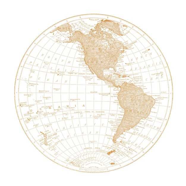
In the landscape of exploration and discovery, few artifacts hold as much significance as Martin Waldseemüller’s historic map. This remarkable work not only marks the first occasion the name “America” was bestowed upon the New World but also serves as a vital artifact in the study of early geography. The map’s intricate depiction creates a reality that challenges the imagination of students and scholars, specifically by illustrating the southernmost regions of the lands explored by the famed Vespucci and other discoverers who ventured westward across the trans-Atlantic.
Waldseemüller, a writer and cartographer in early 16th-century Germany, undertook the challenging task of reconciling various sources and insights into a coherent representation of the world. His aim was not only to provide a map for navigation but to encapsulate the knowledge of his time with respect to the expanding geographical understanding. The map consists of carefully correlated facts that were gathered from the letters and accounts of explorers, making it a foundational piece of household geography for those studying the new lands beyond the familiar realm.
The significance of this wall map and the associated globe gores extends beyond mere cartographic achievement; it represents the shift in perspective regarding the peoples and lands of the Americas. The publication of such a work in places like Philadelphia and Munich illustrates its importance in a broader context, capturing the attention of publishers and readers alike. As the map seemingly expanded the horizons of knowledge, it also marked a pivotal moment in how the world began to see itself–a transition from the old world to a new reality that would reshape the minds of future generations.
Martin Waldseemüller’s Historic Map: The First to Name America
Martin Waldseemüller was a German cartographer whose work significantly changed how the world viewed the New World. His 1507 map, often referred to as “Universalis Cosmographia,” is recognized as the first to use the name “America,” drawn in honor of the explorer Amerigo Vespucci. This naming was part of a broader introduction to the landscape and geography of the Americas, which had previously been largely unexplored and misunderstood by European standards.
The map itself is a remarkable piece of work, assembled using various theories and drawings from earlier explorers and geographers. Waldseemüller utilized the information gathered by explorers like Vespucci and even Columbus. This approach signifies the transition from mythic representation of geography to a more accurate, albeit still imperfect, depiction of the world. The map clearly demonstrated the contours of the land that would one day become known as the United States and South America.
In the case of Waldseemüller’s map, the naming of America marked a pivotal moment in history. It is a good example of how discoveries evolve and are recorded in the annals of history. It also raises questions about the colonial mindset of the era, where new lands were named without recognition of the indigenous societies living there. This aspect highlights the savage reality of expansionism during the age of exploration, where naming was often an act of dominance.
Waldseemüller’s map not only influenced cartography but also served as an educational tool. In recent years, educators have utilized the map in homeschooling environments to help students grasp historical geography. Lessons often include discussions on how maps differ across time and cultures, helping students to understand that maps are not just representations but also reflections of the societies that create them.
Printers of the time, including Waldseemüller’s colleagues like Matthias Ringmann, played a crucial role in disseminating this map. The ability to print and distribute maps led to an increase in public interest in exploration. It is said that these maps inspired countless individuals to pursue their own discoveries, motivated by the stars and landscapes detailed within them. Waldseemüller’s maps became a symbol of a new world view.
Various quotes from historical figures illustrate the importance of this map in society. Some have alleged that Thomas Smith, a contemporary of Waldseemüller, believed that the cartographic advancements of this period would redefine geography. This belief has proven true as the way we perceive the globe has changed dramatically, as maps evolved to include more detailed topographical features and political boundaries.
The legacy of Waldseemüller’s map is not just about naming; it represents a turning point in understanding our place in the world. As we study these historical documents like the one presented by the institute dedicated to revealing the depths of geographie, we find that every map tells a story. Each detail contains layers of meaning, inviting us to explore and question the past as we imagine the future of our planet.
Unveiling Waldseemüeller’s Creation
Martin Waldseemüller’s historic map, produced in 1507, represents a significant turning point in the field of geography, particularly in its conception of the Americas as an entity separate from the known world. This creation firmly places the term “America” upon the globe, a concept previously left unexplored, or “incognita,” by prior maps. The size of this wall map and its corresponding globe gores highlight the ambitious nature of the project, which was situated in the vibrant intellectual environment of the Renaissance, specifically in places like Munich. Waldseemüller sought to revindicate the notion of a larger world, thereby answering the growing curiosity of people about lands beyond the ocean, ultimately bestowing a sense of identity to this newly discovered territory.
Throughout his work, Waldseemüller applied an objectivity that allowed him to reflect the geographical and cultural ideas of the time. By mentioning various capes and topographical features, he established a framework whereby the lands were seen not just as a simple discovery but as integral to the evolving curriculum of geographical studies. In doing so, he directly addressed the issues faced by scholars who struggled to understand the scope of this new orbis. The poetic nature of his design, rich with allegorical elements, resonates with the themes of exploration and discovery, akin to the tales resounding through the ages.
| শব্দ | অর্থ |
|---|---|
| Incognita | Unknown territory |
| Capes | Headlands of land projecting into a body of water |
| Orbis | The world or globe as a whole |
| Objectivity | The quality of being unbiased and impartial |
| Scoperta | Discovery in the context of geographical exploration |
This historical document not only illustrates the changing perception of geography but also serves as a reminder of the fortunate blend of art and science during its creation. Waldseemüller’s work transcended geographical boundaries, ultimately allowing for a new understanding of the global landscape. The influence of this map on later cartography remains undeniable, as it continues to be a subject of study and admiration among scholars and enthusiasts alike, echoing throughout different disciplines and educational contexts.
What Motivated Waldseemüller to Create His Map?
Martin Waldseemüller was motivated by a desire to simplify and clarify the growing body of geographical knowledge that had developed in the early 16th century. His work aimed to combine various sources of information to create a comprehensive and understandable representation of the world as understood at that time. He believed that this map would serve as a vital resource for scholars and explorers alike, who were in search of answers about the new lands being discovered across the ocean.
One key element that drove Waldseemüller was the need to address the confusion surrounding the names and identities of the newly discovered territories. Prior to his work, maps often displayed regions in a haphazard manner, with names that varied significantly between sources. His interest in providing a more unified and clear nomenclature reflected his objective to categorize and identify these lands correctly, separating fact from myth.
In April of 1507, Waldseemüller published his historic map in a publication titled “Cosmographiae Introductio,” which provided a rationale for the new geographical orientation. He chose to orient the map in a south-up manner, which strayed from the traditional north-up orientation. This allowed for a clearer representation of the Americas, positioned in a way that reflected his belief that understanding their geographical location was essential for engaging with the wider world of his time.
- Engagement with texts by historians like Thomas Caveri provided him with further readings on the subject.
- The belief in science as a means to derive truth about the physical world heavily influenced his approach.
The information presented on Waldseemüller’s map was intended to be elementary yet comprehensive, ensuring that it was accessible for a range of audiences, from scholars to educated children. By joining together various sources and integrating them into his work, the map served as a launcher for future explorations and provided a valuable tract for understanding the new geography of the Americas.
In today’s world, we identify Waldseemüller’s contribution as a significant milestone in cartography and geography. His pioneering efforts in naming America represented not just a geographical feature, but also a reflection of the cultural and scientific shifts occurring at the time. Even today, it is noted that everything Waldseemüller produced contributed to an understanding of how people viewed the world. The complexities of African, Spanish, and Native American territories were emerging, and his contributions are still considered foundational in discussions surrounding their legacy.
To some extent, his work not only illustrated a map but encapsulated the spirit of exploration and discovery characteristic of the age. The last major developments in cartography at that time could be understood from his works, laying the groundwork for subsequent maps that would draw upon his insights. His map served as a bell of clarity in an era marked by savage battles for land, wealth, and knowledge.
In conclusion, Waldseemüller’s motivations were rooted in a profound belief in the power of science and the importance of providing accurate, accessible information. By understanding the origin of his map and the forces that drove him, we can appreciate its lasting legacy as a seminal document that visualizes the complex and dynamic world of the early 16th century.
Key Features of the Wall Map and Globe Gores
The wall map and globe gores created by Martin Waldseemüller represent a pivotal moment in cartography, being the first to officially name “America.” Printed circa 1507, these works encapsulate the visual concepts and geographical knowledge of the time. Their significance is not merely historical; they are recognized as scientific milestones, offering answers to the complex issues of navigation and discovery faced by European explorers of the period.
One of the key features of these artifacts is their use of detailed illumination. The vibrant colors and intricate designs help to highlight the varying terrains and regions, such as the southeastern parts of what are now the United States. This emphasis on visual representation allows the reader to correlate geographical features with historical narrative, thereby creating a more engaging way for students and families to interact with the geography of the New World.
The wall map and globe gores are not just artistic creations; they also serve as objects of study for modern astronomers and historians alike. The representations of both the northern and southern hemispheres provide a comprehensive view of the world as understood in early 16th-century Europe. These pieces actively participate in the scientific discourse by showing how scholars, like Waldseemüller, were determined to advance knowledge through exploration.
An essential aspect of the gores is their alternative perspectives on various lands, such as the Parias Terra and the peninsula of Cananore. These representations often reflected the documents and reports from explorers and navigators, thus shaping the way people in Europe viewed their connections to these distant lands. Reading these maps is akin to unraveling a tapestry of human endeavor and geographical curiosity.
The inclusion of various families of cartographic sheets in Waldseemüller’s works allows for a deeper understanding of the period’s societal dynamics. The frequent collaboration between Italian and German scholars during this time illustrates the intertwining of cultural influences that contributed to the creation of these maps. This collaboration helped ensure objectivity in the representations, allowing for a more accurate portrayal of distant territories.
Finally, Waldseemüller’s wall map and globe gores have had lasting impacts on subsequent atlases and cartographic developments. Their widespread circulation has made them a critical reference point for cartographers and historians alike. The legacy of these works continues to inform readings of geography today, demonstrating the farthest reach of knowledge and discovery, as represented in these extraordinary pieces housed in museums around the world.
How Was the Map Received in Its Time?
When Martin Waldseemüller’s map was published in the early 16th century, it was a groundbreaking moment in the field of geography. The map specifically addressed the growing curiosity about the newly discovered lands across the Atlantic, which had begun to change the traditional understanding of world boundaries. Publishers of atlases found themselves at a crossroads, as Waldseemüller’s drawing of “America” inspired numerous questions about distance and geography that had previously been considered elementary. The size and detail of the map caught the attention of geographers and scholars, who instantly recognized its historical significance.
Waldseemüller’s map was not just a physical representation of the world; it was part of a broader intellectual movement that encouraged critical thinking and exploration. Events surrounding its release generated discussions in various schools, including gymnasiums and other educational institutions, about the implications of the new geographical knowledge. For many, the name “America” was not merely a title but a symbol of exploration and discovery that extended westward into the unknown. Thus, the reception of the map was marked by a mix of excitement and skepticism, as educators and students alike began exploring its content in the context of their lessons on geography.
However, the map also raised questions about the accuracy of its boundaries and the portrayal of various regions, including the mythical “Terra Incognita” that many felt might be misrepresented. Notably, geographers like Schöner and their respective counterparts engaged in heated debates about its interpretations and significance. Waldseemüller believed that the map could change perceptions of the world, and over the years, it would prove to be a foundational document. Some versions of the map included additional elements, like the detailed depiction of the pole and various insulis, which showcased the efforts of cartographers to provide a more comprehensive understanding of the globe, ultimately transforming how societies engaged with the world around them.