

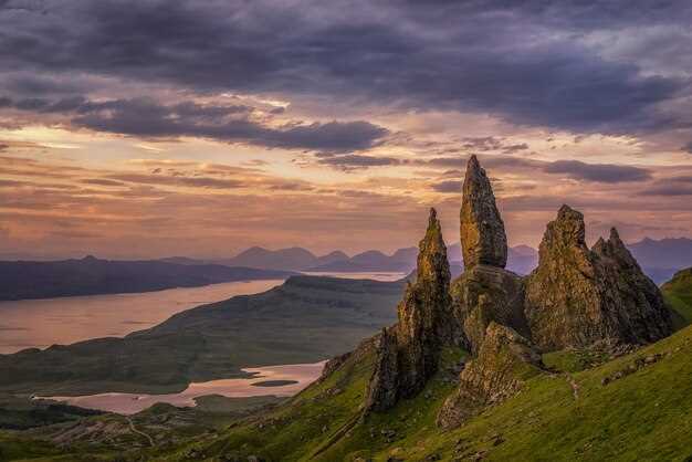
 İngiltərənin Göllər Diyarının Ən Gözəl 10 Məkanı">
Recommendation: Start with Orrest Head for a quick 1.5-mile hill walk that yields a panoramic look over Windermere’s waters. This simple start sets your day up and helps you plan around life on trails while staying close to the neighbourhood. The path is easy to accommodate for families, and you’ll remain comfortable on foot during the ascent.
From there, the ten spots spread into forest paths, lakeside strolls, and dramatic waterfalls. Plan a Derwentwater circuit (about 7 km) that takes 2–3 hours, or a Grasmere and Rydal Water loop of around 4 km for a lighter option. For a splash of motion, follow the Aira Force waterfall trail (roughly 2 km) or circle Wasdale Head to take in Scafell Pike silhouettes. To push farther, tackle the Coniston Old Man route–about 9 km with a steady rise that rewards you with a far-reaching view across Coniston Water. If you want a classic shot, stand between the waters and the hills and watch the light shift. england, a friendly local named donald might share a favorite sunset viewpoint to finish your day.
Balance nature with local neighbourhood life; choose activities that fit your pace and keep the day flexible. Some paths are gentle enough for a stroller; others demand sturdy boots and a plan to return before dusk. Pack a compact rain jacket and a light lunch, and bring a camera to capture light on the waters. If you want a quiet moment, sit on a bench and listen to the birds still in the trees by the shore; between walks, a village café or pub garden helps you map the next stop, making the day feel connected rather than rushed.
Let the list guide you to your favorite day in england, where hills, waters, and friendly faces shape a clear plan. The article that follows breaks each spot into practical tips: best access points, parking, how long to stay, and where to look for the best light. Use these notes to build a day that fits your neighbourhood, pace, and love for life on the lake.
Ambleside-focused plan to visit iconic spots with practical tips
Start with a sunrise stroll from Ambleside along the water and pick pastries at bakeries before you book a morning boating trip to reach iconic spots on the lake.
Stops and leads: Elterwater offers a quiet start, Langdale broadens the scenery, and a short wrynose-side leg yields a dramatic ridge view. A wainwrights path can be added for a gentle ascent, then you reach meres such as Rydal Water and Grasmere for nature-filled, family-friendly strolls. This loop returns to Ambleside and leaves room for plenty photo stops, making each moment feel deliberate rather than rushed.
With children in mind, choose easy paths and keep pace. The first two stops are gentle; when a longer climb appears, turn back. Look for rabbit sightings on grassy verges to keep kids engaged and turn the walk into a simple activity that still feels like a carefully planned day.
Practical tips: book the boating in advance and aim for the early window to reduce crowds; park at Waterside or nearby lots and walk to the boat; pack light rain gear, layers, water, and snacks. The outing took about 3 to 4 hours, depending on how long you linger at Elterwater and the meres. For a quick refresh, pop into Ambleside’s potters and bakeries for a snack, or browse local shops along the way; a short detour to Langdale’s charming lanes adds a memorable touch.
When you finish, thank the day for the chance to feel the place and believe that Ambleside has always welcomed curious visitors. Years of experience show this plan works well for adults and kids alike, and the quiet moments near elterwater water and the surrounding nature leave a lasting impression with highlights that linger long after you’ve headed home.
Getting there: fastest routes from Ambleside to Langdale Pikes, Windermere shoreline, and Rydal Water
From Ambleside, take the southbound signposted route into Great Langdale, park at Langdale Car Park near Stool End, and start the walk up the Mickleden Trail to Pike of Stickle and Harrison Stickle. This is the quickest option for speed and access to the trails, and it gives you everything you need for an amazing day in the countryside. The climb is jaw-dropping, the views under the towering fells are well worth the effort, and you can be back at the car in a few hours if you keep a brisk pace. If you want a longer loop, there’s a honister pass detour you can add next for a bigger, panoramic trip that many others enjoy again and again.
Windermere shoreline – fastest route from Ambleside
- From Ambleside, head toward Waterhead and follow signs along the eastern lakeshore toward Bowness; the route hugs the water and stays well signposted.
- Park near Waterhead or along the lakeside road; if you want a fancier start, hire a rowing boat for a brief spin and see the hills from the water.
- Walk the promenade to soak in jaw-dropping views across Windermere; the scenery is absolutely stunning and often photographed, offering inspiration for your next posts.
Rydal Water – fastest route from Ambleside
- Head south from Ambleside on the A591 toward Grasmere, then turn onto the signposted road toward Rydal; the drive is short and under a canopy of trees.
- Reach the Rydal Water car park and stroll along the lakeside; there are easy trails and plenty of views that are famous among visiting walkers.
- In the centre of the village, you can spend a moment built for relaxation; youd have a chance to pause there, visit locals’ posts, and, if you like, continue along nearby paths for a longer loop with countryside scenery and inspiration for your photos.
Family-friendly lakeside walks near Ambleside: Stock Ghyll, Waterhead, and Rydal park circuits
Begin with Stock Ghyll Gorge for a quick, family-friendly option that sits in a lush forest just above Ambleside. Early starts pay off with quieter paths, and youd enjoy a gentle pace along the stream. The loop runs about 1.5 miles round trip and takes 45–60 minutes, with a mix of level paths and a short boardwalk; heavy gear isn’t needed. Parking is available at the bottom, and a visit can be short if you’re pressed for time, or extended if you want to linger by the mossy banks where old potters sits still in memory of local craft.
Next, head to Waterhead for a flat, lakeside circuit along Windermere’s edge. The route covers roughly 2 miles and typically takes 60–75 minutes at a relaxed pace. You’ll see steamers on the water and, if you time it right, you can combine the walk with a short boating trip. This means a flexible plan for families and others who want variety in a single outing. Parking is nearby, and the surface is smooth enough for strollers, making it easy to keep everyone moving without a heavy uphill detour.
Finish at Rydal Park circuit, a loop through parklands by Rydal Water that clocks in around 3 miles and about 90 minutes for a comfortable family outing. The route includes a gentle summit overlook where you can spot distant gable and honister fells, a moment youd happily share with kids. The lush surroundings invite breaks at quiet corners, taking in views and birds, including migratory species in season. Along the way you might notice mining history in knotts and mardale areas, a nod to local heritage that fits well with a curious family’s day away from the crowds.
| Circuit | Distance (miles) | Approx. time | Terrain & Parking | Əsas məqamlar |
|---|---|---|---|---|
| Stock Ghyll Gorge | 1.5 | 45–60 dəq | Forest path; some steps; parking at bottom | Waterfall, potters yards memory, easy start |
| Waterhead Lakeside | 2.0 | 60–75 min | Flat; lakeside; parking nearby | Windermere views, steamers, boating option |
| Rydal Park Circuit | 3.0 | 90 min | Parkland paths; gentle ascent; parking at Rydal | Summit overlook, gable & honister views, migratory birds |
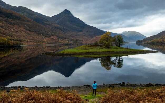
Photo opportunities: optimal times and viewpoints at Loughrigg Terrace, Fell Foot Park, and Windermere
Start at Loughrigg Terrace at first light in summer for the clearest reflections across Windermere. Use a wide-angle lens to capture the terrace wall, the lake, and Langdale in the distance; the stone steps invite a natural foreground, while a low shutter speed can smooth water for a glassy look. Arrive 20 minutes before sunrise to set exposure, and plan a brief stroll along the path to frame birds or passing boats.
Fell Foot Park shines from late afternoon into sunset. Stand on the lawn by the jetty where the water glitters; the wind shifts color on the hills of Langdale and Wrynose in the distance. A vantage near the boat slip yields strong silhouettes of trees and yachts; stay a moment for a calm reflection and, if you want, end with a beer at the riverside cafe.
Windermere edge viewpoints reward calm evenings: walk the east shoreline between Bowness and Ambleside to catch boats crossing the blue expanse; best light appears about 60-90 minutes before sunset in summer, earlier in winter; frame a leading line from the shore toward the distant hills; keep an eye on birds and passing boats.
Practical notes to optimize your shoot: bring a tripod and a compact lens kit; use a polarizer on bright days; keep to paths and avoid crowds on weekends; Loughrigg Terrace offers hidden corners where you can isolate lines or a quiet tree line; a brief Langdale-hill horizon can anchor your composition. This mix gives you everything you need for a successful shot day.
Seasonal edge: if you combine the three spots, plan a light round that fits a family schedule; an overnight stay in the Holker area can extend your photo adventures and give you a chance to photograph misty mornings; youd prefer a relaxed pace for the walk.
Fact: the three locations provide distinct moods, from calm blue water to dynamic skies; the number of reliable photo opportunities is high; noticing how light shifts across the lake helps you build a consistent portfolio; falls and small streams around Loughrigg Terrace add natural texture.
Hidden gems: quieter trails and viewpoints around Ambleside with easy access
Start with Loughrigg Terrace for your first quiet hike – a gentle 3.5 km circuit with few ups and downs and morning light that keeps Ambleside in view and the fells still.
- Loughrigg Terrace Circuit – Məsafə: 3.5 km; Vaxt: 1–2 saat; Hündürlük artımı: ~150 m; Səth: qısa pilləkənləri olan yaxşı işarələnmiş cığırlar; Əsas məqamlar: gölün görünüşü, şam və ağcaqayın örtüyü və Ambleside və ətrafdakı dağların üzərində bir neçə asan baxış nöqtəsi; Giriş: Ambleside şəhər mərkəzindən, A591 yaxınlığında park edin; Ən yaxşısı: xoş, ən az tələbkar dırmaşmaq və təbiətlə sıx əlaqədə olan dövrə hiss etmək istəyən gəzinti həvəskarları üçün.
- Stock Ghyll Force və Riverside Walk – Məsafə: 2.0 km; Vaxt: 40–60 dəq; Yüksəklik artımı: ~40 m; Səth: düz səmt cığırı və kölgəli meşə cığırları; Əsas məqamlar: sakit dərədə gizlənmiş şəlalə, sakit çay səsləri və səhər yaxşı işıq; Giriş: Stock Ghyll avtodayanacağından və ya Ambleside körpüsündən başlayın; Əla seçimdir: bütün səviyyələrdə olan gəzinti həvəskarları üçün nahardan əvvəl tez, asan seçim.
- Tarn Hows Dairəsi – Məsafə: 2.8–3.2 km; Vaxt: 1 saat; Yüksəklik artımı: ~20 m; Səth: əzilmiş çınqıl və taxta döşəmələr; Əsas məqamlar: əks etdirən göl, açıq səma mənzərələri və uzaq təpələr; Giriş: Milli Etimad avtodayanacağı və cığırlar; Məsləhət: izdihamdan qaçmaq üçün tez gedin; Bu məkan uzun dırmaşma olmadan Wainwrights kimi bir atmosfer təklif edir.
- White Moss vasitəsilə Rydal Water döngəsi – Məsafə: 4.0–4.5 km; Müddət: 1.5 saat; Yüksəklik artımı: ~70 m; Səth: ot və yığcam cığırların qarışığı; Əsas məqamlar: sakit su, dalğalı təpələr və vadidən kənarda olan təpələrə doğru baxış nöqtələri; Hələ də mənzərəli görünən rahat dövrə üçün idealdır; Yaxınlıqdakı təpəyə qısa bir dırmanma əlavə etməklə uzatmaq seçimi.
- Knotts qalxma və zirvə yeri – Məsafə: 2.5–3.5 km; Vaxt: 1–1.5 saat; Yüksəklik artımı: ~120 m; Səth: yumşaq yamacları olan otlu cığırlar; Əsas məqamlar: şamlıqdan keçən yol, yüngül dırmanma və uzaq mənzərələri olan gözəl təpə; Çox səy göstərmədən bir az daha çox şey istəyən gəzinti həvəskarları üçün uyğundur.
Daha uzun bir seçim istəyirsinizsə, alternativ olaraq Holkerdən keçən, incə bir təpə hissəsi və yerli sakinlərlə qaymaq sifariş edə və söhbət edə biləcəyiniz bir kənd kafesi dayanacağı üçün bir döngə planlaşdırın. Ən yaxşı nəticələr üçün Ambleside-ın qərb ucuna yaxın yerdə görüşün və həmin səhər necə hiss etdiyinizə əsaslanaraq bir marşrut seçin; səhərlər daha sakit keçir və bu sakit yerlərdə atılan hər addımda zehniniz təmizlənir.
Səyahətə hazırlıq: parkinq, hava proqnozunun yoxlanılması, avadanlıq siyahıları və ən yaxşı yerləri ziyarət etmək üçün təhlükəsizlik məsləhətləri
Paka gəzinti yolunun yaxınlığındakı rəsmi dayanacaqlarda edin və tez gəlin; əsas dayanacaq dolarsa, yaxınlıqdakı əlavə ərazidən istifadə edin və ən işlək girişlərdən uzaqda park edin.
Yola çıxmazdan əvvəl etibarlı proqnozdan öz yeriniz üçün havanı yoxlayın; noyabr ayında xüsusən yüksək marşrutlarda külək, çiskin və sürətli dəyişikliklər gözlənilir.
Açıq hava üçün dişli siyahısı: möhkəm, suya davamlı, tutuşlu çəkmələr; yağış gödəkcəsi və izolyasiya qatları; isti papaq və əlcəklər; xəritə və kompas və ya oflayn GPS; baş fənəri, fit, kiçik ilk yardım dəsti, qəlyanaltılar və kifayət qədər su. Yüngül quru çanta və təcili yardım battaniyesi daxil edin; çantanızı planlaşdırdığınız fəaliyyətlərə uyğunlaşdırın - sürüşmə, kəşf etmə və ya asan gəzinti, çəkini idarə oluna bilən və tempinizi sabit saxlamaq üçün. Daha yüngül çanta yolda gördüyünüz işi azaldır.
Təhlükəsizlik hər şeydən öncə: işarələnmiş yollarla gedin, dar hissələrdə kənarda durun və açıq kənarlarda dırmaşmaqdan çəkinin; planınızı və gözlənilən qayıdış vaxtınızı kiməsə deyin; qarşılaşdığınız hər kəslə nəzakətlə görüşün və mal-qara olan yerlərdə itlərinizi qandala bağlayın. Əgər yenidən qurulmuş və ya qeyri-sabit yerlə qarşılaşsanız, yavaşlayın və yenidən qiymətləndirin – əgər külək və ya şərait dəyişərsə, sakitləşənə qədər hərəkətsiz qalın. Yerli mühafizəçilər və icmalar qaydalara əməl edən ziyarətçilərin yaratdığı etimada güvənirlər.
Parklanma və gecələmə məsələləri: bəzi yerlərdə sakit kənarlarda pulsuz parklanma təklif olunur; əks halda, gecələmə qaydaları və ödənişləri üçün təyin edilmiş yerlərə və işarələrə əməl edin; əgər gecələməyi planlaşdırırsınızsa, icazə verilən düşərgələrdə və ya daxmalarda əvvəlcədən rezervasiya edin.
Loughrigg dairəsi kimi marşrutlar üçün ətrafdakı mənzərələri görmək üçün aşağı nöqtədən başlayın və yüksəlişdə və bataqlıq hissələrdə tempinizi tənzimləyin; bu əsl yüksəklik diqqətli vaxtlama və yaxşı ayaqqabılarla mükafatlandırır.
Köhnə mədən qurğularının ətrafındakı heyvanlara və həssas ərazilərə diqqətli olun; vəhşi təbiəti narahat etməyin, hasarlanmış ərazilərdən kənarda durun və gətirdiyiniz hər şeyi özünüzlə aparın. Orada diqqəti cəlb etməyin və insanların açıq havada əyləndiyi sakit yerlərə hörmət edin.
Nəhayət, bu məkanların cazibəsi insanlar cığırda hörmətli, sakit anlar paylaşdıqca artır; əgər yolda kimsə ilə qarşılaşsanız, səmimi salamlayın, məsləhətlər mübadiləsi aparın və başqalarına öz yerlərindən həzz almağa imkan vermək üçün növbəti dayanacağa çatana qədər yolunuza davam edin. Bu yolları başqaları üçün təmiz saxlamaqda dəyər var.