


Kick off with schlitterbahn in New Braunfels, then plot five routes that blend Prada-like style with tumbleweed drama along the Rio Grande. You will capture memorable moments outside the city and have year-round options that fit any weekend.
From San Antonio, New Braunfels is about 30 miles away, Gruene sits a 40-minute detour, and Fredericksburg is roughly 70 miles away, respectively. In Gruene, live music fills Gruene Hall on weekends, and schlitterbahn offers an ተወሳኺ splash option before you head onward. For hotels, choose a central inn in Fredericksburg or a boutique stay in Gruene; expect rates around $140–$260 per night on weekends, and plan a round trip break if you want a longer day.
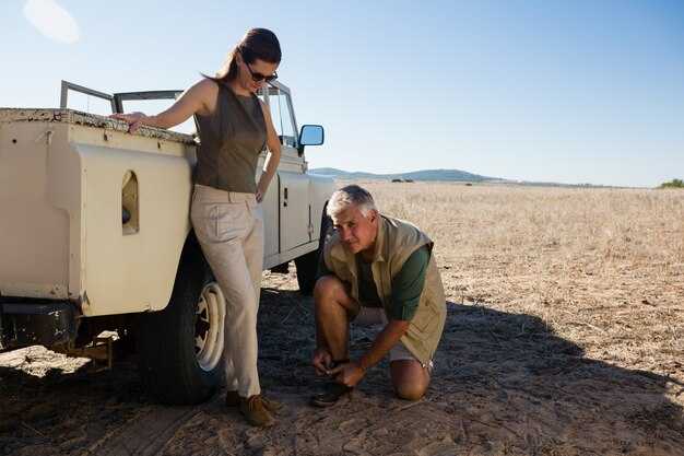
Fredericksburg rewards slow strolls along Main Street, German cafés, and wine rooms, then Enchanted Rock offers a 1.5–2 mile round trip hike with a sunrise glow. If you travel with a school group, the National Museum of the Pacific War offers accessible exhibits that fit a short visit between meals. Personally, I decided to time the rock climb for pre-dawn so the granite blushes, and I like a coffee somewhere along the Main Street corridor to start the day. For drinks, try a late-afternoon sip on a shaded patio before driving north to the next point of interest.
West Texas greets you with Marfa’s galleries and the Prada Marfa installation, a must for fashion-minded travelers. Drive through the Trans-Pecos to Alpine or Marfa, where El Cosmico offers a quirky, budget-friendly stay under the stars. Points of interest include the Chinati Foundation, the Marfa Lights, and bold mural scenes. Hotels range from small inns to renovated ranch houses; plan two nights to catch sunset and a dawn coffee, and bring a camera to capture the sky’s color shifts. Personally, I suggest booking ahead, as weekends fill quickly.
From Marfa, head toward Big Bend along Fort Stockton, Marathon, and Terlingua. The Rio Grande corridor features Santa Elena Canyon and the Window Trail, with long, quiet roads and dramatic desert views. Lodging options include Chisos Mountain Lodge inside the park and Lajitas Resort for stargazing. A slow morning hike followed by a river view makes a strong case for a two-night stay in this zone; water and sun protection are essential, especially in summer. The round distance from San Antonio varies by route, but plan roughly 550–600 miles if you loop back through the Hill Country.
Finish with a coast-hugging arc: San Antonio to Corpus Christi, about 150–170 miles, then a short drive to Port Aransas for beaches, fishing, and fresh seafood. In Corpus Christi, pick a bayfront hotel such as Omni Corpus Christi or a boutique property to stay year-round, then spend an evening to drink local craft beer at a waterfront spot. A day trip to Port Aransas keeps the pace slow and easy, with wind-swept shorelines that invite strolls somewhere along the jetty. Key stops include the USS Lexington museum and Padre Island National Seashore, respectively.
San Antonio Road Trip Guide
Start in austins on fridays for a tight, 2-day loop: south to san antonio, then back via the river road. This setup keeps the area outside the city accessible and fuels quick, memorable stops along the missions, towns, and scenic overlooks.
Where the road runs along the river, you find a line of destinations that makes sense for a quick escape, mixing city energy with open-country views. The plan respects your pace and helps you feel the sense of Texas outside the city limits.
Itineraries
- Two-day South Loop
Distance: ~180 miles. Start in austins on fridays, drive south to san antonio, explore the missions and the River Walk, then loop back through Gruene and New Braunfels. This route keeps you close to the river and offers easy day hikes and kid-friendly stops.
- Three-day River and Missions Circuit
Distance: ~230–260 miles. Add Kerrville and Fredericksburg for alpine-like overlooks, then stitch in a couple of Mission stops along the way. This itinerary continues through small towns and adds a relaxed pace with plenty of detours for scenery and photos.
- Devils River Extension
Distance: ~300+ miles. Extend west toward canyon roads and the Devils River area for rugged scenery. Bring a spare tanker of water and plan campground stays; trailers benefit from ahead-of-time reservations and level spots.
Stops and destinations
- San Antonio Missions National Historical Park, River Walk, and King William district for rich history and walkable lanes.
- New Braunfels, Gruene, Seguin, and Seguin’s local barbecue stops offer bite-size taste of the area you love.
- Kerrville and Fredericksburg for scenic byways and gentle alpine-like panoramas that lift the mood of the trail.
- Devils River area for a half-day paddle or a short hike if you crave more adventure outside the city core.
Trail notes and practical tips
- Trail segments along the Medina River and surrounding hill-country byways deliver a calm rhythm that suits both city lovers and outdoor enthusiasts.
- Whether you travel with tents, a few camp chairs, or trailers, plan ahead for camping spots and park hours, especially on fridays when spots fill fast.
- If you get lost, reorient at a gas station or a well-marked turn; keep a map as a backup to your phone.
- Details on lodging range from downtown hotels to small-town inns and RV parks; reserve ahead if you’re chasing weekends or holidays.
- Area-independent pace works well for families and solo travelers alike; this route continues to offer new sights without long drives each day.
Ideal departure times and pacing for a day trip
Depart at 7:00 am from San Antonio to set the pace and gain daylight. This early start makes the day easier and leaves room for unexpected detours.
Through texass rolling plains toward Floresville, plan a 45-minute stop for coffee and a quick stroll along the rivers to stretch your legs.
From Floresville, the drive to Brenham becomes the backbone of the day, a steady 2-hour stretch with a couple of quick runs for photos.
Arrive Brenham around 11:30–12:15 and choose from restaurants with brisk service and diverse cuisine. Most spots opens around 11:30–12:00, so pick a quick option and wrap within 45–60 minutes.
After lunch, head toward Padre for a change of scenery; the route passes desert stretches and massive skies, with a few pull-offs to capture the river vistas and farm paths.
Toward the late afternoon, begin the return on a steady path that keeps your energy up; when you havent planned a longer road day, instead head back via nearby routes.
If you hit purgatory midafternoon, shift to a shorter final leg; such suggestions keep energy steady and your day becomes manageable.
Top Prada Amid the Tumbleweeds photo spots and landmarks
Begin at Prada Marfa for your must-get shot; the installation sits along US-90 east of Marfa, quietly framing the tumbleweed breeze under wide desert skies.
From there, plan a seven-stop loop that blends sculpture, history, and canyon light into compelling images. Chinati Foundation lines up bold Judd works against vast horizons, the Marfa Lights Viewing Area adds atmospheric orbs at dusk, Fort Davis delivers military-era fortifications in a stunning high-desert setting, and Santa Elena Canyon along the Rio Grande brings water and dramatic canyon walls into focus. elena, a Marfa-based photographer, reminds you arrival timing changes how bands of color appear, so know your light window and be ready to adjust.
Because light shifts quickly here, you should arrive early for dawn textures and stay to catch golden-hour glows. In practical terms, aim for soft tones around six to eight in the morning and again two hours before sunset; this cadence yields clean silhouettes and avoids harsh shadows, especially on adobe walls and steel structures. Within each site, you’ll learn how to frame negative space with the sky and how to let minimal lines carry the eye, which makes the tumbleweed mood feel intentional rather than accidental.
To balance your outdoor shoots with a taste of local culture, include a stop along the small-town chain of galleries and cafes in Marfa. They offer quick portraits against storefronts and signage that tell the south Texas story, and you’ll find opportunities to sample cuisine and seafood options at spots near the plaza after a day of exploring. Those breaks help your eyes reset and preserve energy for what comes next in your adventures, and they’re part of the annual rhythm that makes these trips feel like a curated experience rather than a single day.
For planning, keep in mind that the best times vary by season and weather, so check the issuer or local desk for access notes if you plan interior shoots or clips at restricted areas. They know the exact hours for guided blocks and can point you toward the most photogenic angles along the way. When you wrap up a day, the stretch back toward Houston with gulf coast seafood options provides a satisfying end to the route, offering a chance to compare river reflections, canyon textures, and city lights–all while you capture the mood of Prada amid the tumbleweeds.
Below is a quick reference to the top spots and what to expect at each.
| Spot | Location | Best Angle/Feature | Best Time | Pro Tips |
|---|---|---|---|---|
| Prada Marfa | US-90 east of Marfa (near Valentine) | Clean silhouette against wide sky and open line of road | Dawn or golden hour | Respect posted rules; use a long lens for compression; issuer notes may apply for access at certain hours |
| Chinati Foundation | Marfa | Judd concrete blocks with desert backdrop | የመሽት ሰዓት | Bring a tripod for low light; plan a short walk between installations for varied compositions |
| Marfa Lights Viewing Area | West of Marfa on US-90 | Orbs rising on the horizon with horizon line in frame | ድንግዝግዝታ እስከ ሰማያዊ ሰዓት | Arrive with patience; use a low ISO and tripod for steady sequences |
| Fort Davis National Historic Site | Fort Davis, high desert plateau | Parade ground and distant hills with stone architecture | ብርሃነ ንጋሕ | Combine with nearby overlooks; consider military-era textures for strong verticals |
| Davis Mountains / Davis Mountains State Park | Near Fort Davis | Ridge lines and silhouette with canyon spill | Midday to late afternoon (differs by season) | Carry water, stay on trails; pack a neutral density filter for rock faces |
| Santa Elena Canyon | Big Bend National Park | Canyon walls reflecting in the river; dramatic opening to sky | የመሽት ሰዓት | Bring water, sunscreen, and sturdy shoes; watch for weather changes near the river |
| Elena’s Studio / Local Gallery Stop | Marfa center | Window light on textiles and art objects | Twilight to night | Chat with elena’s team about upcoming annual shows; this adds context to your portraits |
Floresville Loop: must-visit stops for food, farms, and scenery
Begin with a quick coffee on Main Street and a pastry at the Floresville Café, then tackle the Floresville Loop clockwise for about 40 miles of food, farms, and river views.
Stop 1: Riverside Ribs & Brisket fuels the day with slow-smoked ribs, brisket, and hand-tossed tortillas from a nearby grange-supported farm. Sit outside and watch the Wilson Creek bend while the scent of smoke lingers. For a busy schedule, delivery trays travel to your car or pickup spot, saving you minutes between bites and views.
Stop 2: Wilson County Farms & Markets line the route with peaches, peppers, greens, and fresh eggs. These stands are among the largest in the area during peak season, and you can print this route to plan the best order of visits. Bring a cooler for the ride home and consider a farm box subscription so you get delivery to your home each week.
Stop 3: River Bend Overlook sits above a bend in the river, where the hills roll toward the horizon. A pull-off offers a short walk to springs and a photo-friendly bank for images. The quiet moment here contrasts with the town’s bustle and makes a perfect pause before the next stop.
Stop 4: Floresville Grange & Town Center reflects a compressed view of america and its rural life: a compact grange hall, a vintage general store, and a small museum. Editorial notes in the local paper highlight these places for their craft, woodwork, and community events. A note from jennifer in the editorial desk highlights this loop’s family-friendly pacing. For a quick memory, snap photos, print one copy, and tuck it into your wallet as a keepsake.
Plan a roughly 2.5–3 hour loop with about 40 miles of drives that weave outside the city limits. These drives offer levels of scenery, from sunlit fields to shaded lanes, and they reward your time with fresh flavors, home-grown produce, and character-filled town vibes. If you crave more, a short detour toward Brenham expands the loop into a longer day of farms, rivers, and joyful roads across america.
Route logistics: distances, fuel stops, and road safety
Start with a fuel plan: fill before you depart San Antonio, then target stations at roughly 120–150 miles apart to stay in control. Stations along I-37 S and TX-35 corridors offer regular, mid-grade, and diesel, plus snacks and drinks. They provide quick access to restrooms and basic maintenance. Carry an information card with tire pressures and emergency contacts, and log each top-up to track loads and home-base timing. A simple checklist keeps you moving smoothly, and a quick map helps you identify the next station before you run low.
The coastal loop runs San Antonio to rockport (about 190 miles/305 km). After reaching rockport you can refuel, restock gear, and head inland to Corpus Christi (roughly 30 miles/48 km). From there plan a barton-stop for another cluster of stations and a chance to grab drinks and snacks. If you bring a boat, check ramp times and marina fuel docks to avoid waiting. A jacobs pause can add supplies and a few editorial notes for the road. Keep 2–3 legs between big towns and load the car so you avoid slowing down for roadside checks.
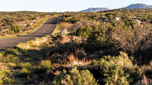
On the Hill Country leg, bluebonnets peak in spring and offer scenic overlooks where you can stretch legs, check shocks and tires, and adjust loads. If you slot in a winery stop, you gain a unique break that balances scenery with practical needs; the editorial tone helps you caption ideas for your logbook. For safety, keep speeds aligned with posted limits, watch for wildlife near dusk, and maintain a steady following distance. In most itineraries, Texas Hill Country wineries provide a welcome pause that adds character to the trip.
Safety and logistics in one glance: carry water and a small toolkit, a spare tire, jack, and basic supplies. Before long stretches, plan 10–15 minutes for a quick fuel/top-up and a check of wheels, brakes, and fluids. Keep a home-point in mind and stay flexible to shift to a shorter route if weather or traffic spikes. If you encounter a crosswind, slow down, use an overlook to regroup, and resume with caution toward rockport or your next stop. This approach minimizes delays and keeps you on track for a smooth, enjoyable drive.
Seasonal timing: weather, heat, and closures to watch
Plan your roadtrips for late spring or early fall–April or October–so you get milder afternoons and fewer closures. Aim for a Saturday arrival to stretch your weekend, then head along back roads toward pedernales and rockport. This window keeps daytime highs comfortable for hiking, lets you savor the cuisine at each spot along the way, and offers a nice balance for family.
Weather shifts by month: spring thaws give mild days with cooler mornings; summer pushes temps past 95°F, turning an afternoon drive into a muggy crawl with heavy traffic on major corridors. In the Hill Country, springs feed creeks that swell after storms, so check forecast and park alerts before you head out. If you target a saturday arrival, map routes to dodge peak traffic.
Coastal plans around mexico border towns add variety: rockport to the coast makes sense in fall, when gulf winds cool evening breezes; closures may pop up in late summer hurricane season, so adjust plans for the afternoon and opt for indoor options if storms roll in.
pedernales and the area require flexible timing: some trails close after heavy rains; check their spot forecast and road status before departing, especially on a long roadtrip that includes back roads.
Food and wildlife: for family trips, sample local cuisine in city hubs, then delivery from nearby delis or restaurants for a quick meal after a long drive; drink water, carry sunscreen, and a good bottle for refills to stay hydrated during hot days.
annual snapshot: March through May offer comfortable temps and wildlife viewing along rivers; June through August demand shade and early starts; September through November bring pleasant evenings and fewer crowds; December through February bring cooler nights and occasional mist along the coast.